 Filter: Categories of Wisconsin Historical Images
Filter: FULL_DATE of 1933
Filter: Subject of michigan, lake
Filter: Categories of Wisconsin Historical Images
Filter: FULL_DATE of 1933
Filter: Subject of michigan, lake
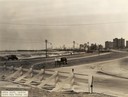
| Date: | 1933 |
|---|---|
| Description: | View from Outer Lake Shore Drive looking south from Foster Avenue. Lake Michigan and the Chicago skyline are in the background. |

| Date: | 1933 |
|---|---|
| Description: | This map shows the physical geography and basic geological features of Wisconsin and includes a geological cross-section from Lake Pepin to Lake Michigan a... |

| Date: | 1933 |
|---|---|
| Description: | This road map shows state and county roads in Wisconsin, northern Illinois, northeastern Iowa, eastern Minnesota, and the western portion of Michigan's Upp... |

| Date: | 1933 |
|---|---|
| Description: | This map of Wisconsin and eastern Minnesota identifies federal and state highways in the area. Railroads are shown with the mileage between stops indicated... |

| Date: | 1933 |
|---|---|
| Description: | This map shows the state trunk highway system and county trunk highways. This map show surface type on state and county trunk highways and the locations of... |
| Date: | 1933 |
|---|---|
| Description: | This map shows cities, rivers, lakes, roads, county boundaries, and destinations. Scenic and historic trails are shown in red. The map includes indexes to ... |

| Date: | 1933 |
|---|---|
| Description: | A road map of Wisconsin, that shows the major and some minor roads of the state, population of the cities and towns, a scale and an index. The reverse side... |

| Date: | 1933 |
|---|---|
| Description: | This road map shows automobile routes across Wisconsin as well as portions of Illinois, Minnesota, Iowa and Michigan. Lakes Michigan, Superior and Winnebag... |

| Date: | 1933 |
|---|---|
| Description: | This map contains automobile routes across Wisconsin and portions of Illinois, Iowa, Minnesota and Michigan as well. The state borders are clearly defined... |

| Date: | 1933 |
|---|---|
| Description: | Elevated view of a stretch of beach and a factory with a smokestack along Lake Michigan. Caption reads: "Shoreline at Manitowoc, Wis." |
If you didn't find the material you searched for, our Library Reference Staff can help.
Call our reference desk at 608-264-6535 or email us at: