 Filter: Categories of Wisconsin Historical Images
Filter: FULL_DATE of 1932
Filter: Subject of rivers
Filter: Categories of Wisconsin Historical Images
Filter: FULL_DATE of 1932
Filter: Subject of rivers
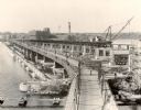
| Date: | 1932 |
|---|---|
| Description: | Elevated view of the bridge over a river. The Nicolet Paper Company is at the end of the bridge on the far shoreline. |
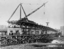
| Date: | 1932 |
|---|---|
| Description: | View of the bridge under construction, with a crane atop the structure. Eight men are standing on scaffolding below the bridge. The Nicolet Paper Company ... |

| Date: | 1932 |
|---|---|
| Description: | This map includes a distance table, text, and insets maps of, Superior, Ashland, Marinette, Green Bay, Appleton, Manitowoc, Oshkosh, Fond Du Lac, Janesvill... |
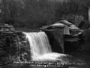
| Date: | 1932 |
|---|---|
| Description: | Exterior view of Taliesin and its hydroelectric plant. Caption on photograph reads, "Dam at Frank Lloyd Wright's Bungalow-Taliesin-near Spring Green, Wis."... |
| Date: | 1932 |
|---|---|
| Description: | View across water of The Flowage showing the Mercer Fish Hatchery building on the left. Two people are in a boat on the far left, a bridge is in the center... |
| Date: | 1932 |
|---|---|
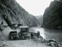
| Description: | Men stand along a riverbank as International trucks are used to haul loads from the cliffs during the construction of the Hoover Dam. An electric shovel is... |
| Date: | 1932 |
|---|---|
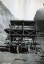
| Description: | Front view of a three-deck drilling platform mounted on an International truck. The device was used in the interior of the tunnels during construction of t... |
| Date: | 1932 |
|---|---|
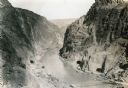
| Description: | Elevated view looking north toward the future site of the Hoover Dam. |

| Date: | 1932 |
|---|---|
| Description: | This map of Superior shows many points of interests including camping, fair grounds, docks, tourist attractions, lakes, roads, and waterways. |

| Date: | 1932 |
|---|---|
| Description: | This map of Beaver Dam shows new boundary lines for wards, existing wards, roads, railroads, and rivers. Roads and Beaver Dam Lake are labeled. There are s... |

| Date: | 1932 |
|---|---|
| Description: | This map shows automobile routes across Wisconsin and parts of Illinois, Michigan, Minnesota and Iowa. The Mississippi River, Lake Michigan, Lake Superior,... |
| Date: | 1932 |
|---|---|
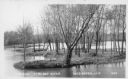
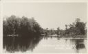
| Description: | Text on front reads: "Island Baraboo River Reedsburg, Wis." View of a tree and grass covered island on the Baraboo River. |
| Date: | 1932 |
|---|---|
| Description: | Text on front reads: "The Valley of the 'Oconto', Stiles, Wis." The shoreline is lined with trees. The Oconto River flows into Green Bay. |
If you didn't find the material you searched for, our Library Reference Staff can help.
Call our reference desk at 608-264-6535 or email us at: