 Filter: Categories of Wisconsin Historical Images
Filter: FULL_DATE of 1931
Filter: Subject of lakes
Filter: Categories of Wisconsin Historical Images
Filter: FULL_DATE of 1931
Filter: Subject of lakes
| Date: | 1931 |
|---|---|
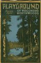
| Description: | Cover of a Wisconsin tourism pamphlet for the 1932 season. |
| Date: | 1931 |
|---|---|
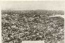
| Description: | Aerial view of the city. Caption reads: "The finest aerial view of Oshkosh, Wis. ever made. Practically the entire town is included in this comprehensive p... |

| Date: | 1931 |
|---|---|
| Description: | Three boys playing in the water near the shoreline with their pants rolled above their knees. A fourth boy is squatting on the grassy shore, poking one of ... |

| Date: | 1931 |
|---|---|
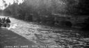
| Description: | View down lake shoreline on Lake Manitowish at Little Bohemia. There are stairs coming down to the lake, and a bench, as well as docks, a flag pole and a d... |

| Date: | 1931 |
|---|---|
| Description: | Two metal rowboats are pulled up on the shoreline of Lake Wilipyro. The lake and trees on the opposite shore are visible in the background. A small animal... |

| Date: | 1931 |
|---|---|
| Description: | View across water of people standing on the shoreline and a dock. Two people are in a boat on the lake. Cooper Cottage is visible on land and another dock ... |
| Date: | 1931 |
|---|---|
| Description: | View of the Squaw Bay Caves, near Cornucopia, with people in a boat off to the far left. The caves were renamed Mawikwe Bay, and Mawikwe is Ojibwe for weep... |
| Date: | 1931 |
|---|---|
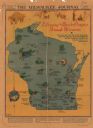
| Description: | This map "sets out the more important points of historic interest designated by the National Society of Colonial Dames in Wisconsin" and includes illustrat... |
| Date: | 1931 |
|---|---|
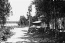
| Description: | View down drive towards lake. The front porch is behind a grove of trees where automobiles are parked out front of the Northwood's Beach Hotel on Lake Cour... |

| Date: | 1931 |
|---|---|
| Description: | View from the water of three boys on the dock at the foot of a steep stairway. There is a large roofed landing with benches half way up the hill, and many ... |

| Date: | 1931 |
|---|---|
| Description: | View from lake of a few boys on a dock as well as four wooden boats pulled up along the dock or the shoreline. There is a diving platform at the end of the... |
| Date: | 1931 |
|---|---|
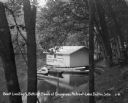
| Description: | A boathouse and canoe boats along Lake Delton. The boathouse is painted with advertisements that read, "Cottages - Rooms - Cabins - Refreshments - Free Cam... |

| Date: | 1931 |
|---|---|
| Description: | This U.S. Geological Survey map of Wisconsin shows counties, cities and villages, lighthouses, Indian reservations, military reservations, and bird and gam... |

| Date: | 1931 |
|---|---|
| Description: | This map of south central Wisconsin shows lakes, rivers, cities, villages, highways and roads, railroads, Indian mounds, and points of scenic and historic ... |

| Date: | 1931 |
|---|---|
| Description: | A topographical map from the U.S. Army Corp of Engineers showing the topography and man-made features in the Camp Williams area of the towns of Orange and ... |
| Date: | 1931 |
|---|---|
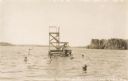
| Description: | View across water of men and children swimming around and diving off of a diving platform at Lakewoods Resort on Namakagon Lake. In the distance is the far... |

| Date: | 1931 |
|---|---|
| Description: | Scenic view from shoreline over Namakagon Lake towards the opposite shoreline. There are two large buildings nestled among trees with a pergola on the lawn... |
| Date: | 1931 |
|---|---|
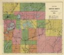
| Description: | This 1931 map of Sawyer County, Wisconsin, shows the township and range system, towns, sections, cities and villages, railroads, highways and roads, and la... |
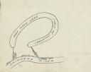
| Date: | 1931 |
|---|---|
| Description: | Prepared by Robert K. Boyd for his article "Up and down the Chippewa River" which appeared in the March 1931 issue of the Wisconsin Magazine of History, th... |

| Date: | 1931 |
|---|---|
| Description: | Relief shown by contours and spot heights. Maps shows United States, state, county and local highways and roads, schools, North Bend, creeks, lakes, rivers... |
If you didn't find the material you searched for, our Library Reference Staff can help.
Call our reference desk at 608-264-6535 or email us at: