 Filter: Categories of Wisconsin Historical Images
Filter: FULL_DATE of 1930
Filter: Subject of mississippi river
Filter: Categories of Wisconsin Historical Images
Filter: FULL_DATE of 1930
Filter: Subject of mississippi river

| Date: | 1930 |
|---|---|
| Description: | View of town on opposite shoreline, and piers in the foreground on the right. Taken from the Burlington Railroad bridge. |
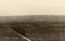
| Date: | 1930 |
|---|---|
| Description: | Elevated view of the north side of town, from high on the bluff. Caption reads: "'Birdseye' No. End Prairie Du Chien, Wis." |
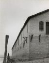
| Date: | 1930 |
|---|---|
| Description: | View looking up at a corner of the Diamond Jo warehouse. |

| Date: | 1930 |
|---|---|
| Description: | View across railroad tracks towards the Diamond Jo warehouse. A bridge over the Mississippi River is in the background. |
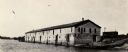
| Date: | 1930 |
|---|---|
| Description: | View across Mississippi Rover towards the Diamond Jo warehouse along the shoreline. |
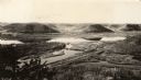
| Date: | 1930 |
|---|---|
| Description: | Elevated view of Perrot State Park (Trempealeau vicinity) looking west from Brady's Bluff toward the Mississippi River and Minnesota. Railroad tracks run a... |

| Date: | 1930 |
|---|---|
| Description: | Aerial view looking east at Mt. Trempealeau from Brady's Bluff in Perrot State Park. The Mississippi River is visible along the bluffs at upper left, and t... |

| Date: | 1930 |
|---|---|
| Description: | Pen and ink map on paper of Wisconsin and northern Illinois showing stagecoach routes (marked in red) that traveled between Lake Michigan and the Mississip... |

| Date: | 1930 |
|---|---|
| Description: | This map shows the state trunk highway system and county trunk highways. This map show surface type on state and county trunk highways and the locations of... |
If you didn't find the material you searched for, our Library Reference Staff can help.
Call our reference desk at 608-264-6535 or email us at: