Filter: Categories of Wisconsin Historical Images
Filter: FULL_DATE of 1924
Filter: Creator Name of Unknown
Filter: Subject of land
Filter: Categories of Wisconsin Historical Images
Filter: FULL_DATE of 1924
Filter: Creator Name of Unknown
Filter: Subject of land

| Date: | 1924 |
|---|---|
| Description: | Aerial view of Madison's Willow Beach towards the University of Wisconsin-Madison campus, downtown Madison, and Lake Monona. |

| Date: | 1924 |
|---|---|
| Description: | Front and back covers of Scenic Wisconsin Motorways, a guide to Wisconsin roads compiled by Victor F. Pettric and published by the Wisconsin Motorists Asso... |
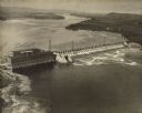
| Date: | 1924 |
|---|---|
| Description: | Aerial view of the Prairie du Sac hydroelectric plant and the surrounding landscape of the Wisconsin River. |
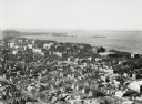
| Date: | 1924 |
|---|---|
| Description: | University of Wisconsin-Madison lower campus and the surrounding neighborhoods. Lake Mendota and Picnic Point are in the background. |
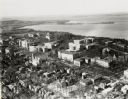
| Date: | 1924 |
|---|---|
| Description: | University of Wisconsin-Madison aerial view overlooking the lower campus and surrounding neighborhoods. Lake Mendota and Picnic Point are in the background... |
| Date: | 1924 |
|---|---|
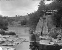
| Description: | Elevated view of The Dells. A group of people are standing on a rock formation on the right overlooking the river. On the left is a rocky shoreline, and in... |
| Date: | 1924 |
|---|---|
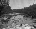
| Description: | Elevated view looking upriver at The Dells. Trees and plants are along the shoreline. |

| Date: | 1924 |
|---|---|
| Description: | This map is pen, pencil, and watercolor on paper and shows land ownership by name, local streets, railroads, and part of Chequamegon Bay. The map includes ... |

| Date: | 1924 |
|---|---|
| Description: | This map shows streets, selected buildings, railroads, railway yards, schools, parks, schools, cemeteries, bays, the Milwaukee River, and Lake Michigan. De... |
| Date: | 1924 |
|---|---|
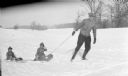
| Description: | Herbert Paul Brumder is pulling his two sons, Herbert Edmund, center, and Philip George, left, on a toboggan in a snowy, rolling landscape. The two boys ar... |

| Date: | 1924 |
|---|---|
| Description: | A small group is filling in part of the Archibald Lake shoreline with branches to protect the point from erosion. Names from left to right: Pete Blanchard,... |
If you didn't find the material you searched for, our Library Reference Staff can help.
Call our reference desk at 608-264-6535 or email us at: