 Filter: Categories of Wisconsin Historical Images
Filter: FULL_DATE of 1923
Filter: Subject of cities and towns
Filter: Categories of Wisconsin Historical Images
Filter: FULL_DATE of 1923
Filter: Subject of cities and towns

| Date: | 1923 |
|---|---|
| Description: | Rear view of Sterling Hall on the University of Wisconsin-Madison campus. |
| Date: | 1923 |
|---|---|
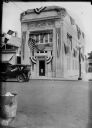
| Description: | Exterior view from across street of the People's State Bank decorated to honor the 250th anniversary of the discovery of the Mississippi River. |
| Date: | 1923 |
|---|---|
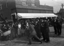
| Description: | A street gathering of people interested in using war-salvaged explosives for a land clearance program. |
| Date: | 1923 |
|---|---|
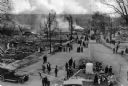
| Description: | Overhead view of a crowd, consisting of men, women, and children standing among what appears to be charred ruins. Smoke is rising in the background. |
| Date: | 1923 |
|---|---|
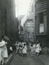
| Description: | Children joining hands while playing in an alleyway between brick buildings in an area of tenement housing. A line of laundry suspended over the alley is h... |

| Date: | 1923 |
|---|---|
| Description: | Photographic postcard of scenes from Alma. Three scenes from areas around Alma show the town along the Mississippi River, an elevated view of the river bet... |
| Date: | 1923 |
|---|---|
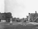
| Description: | A retail street at the intersection of East Oat Avenue. Cars and trucks are parked in the middle of the street. The shops are: a drugstore, Guernsey's Bake... |
| Date: | 1923 |
|---|---|
| Description: | A retail street at the intersection of East Oat Avenue. Cars are parked in the middle of the street. The shops are: a restaurant, Guernsey's Bakery, a drug... |
| Date: | 1923 |
|---|---|
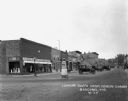
| Description: | View down retail street. The shops include a clothing store, Barig and Son Undertakers, a hotel, and drugstore. Cars are parked in the middle of the street... |

| Date: | 1923 |
|---|---|
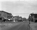
| Description: | A busy street scene on Main Street and Wisconsin Avenue. Cars are parked in the middle of the street, and triangle flag banners hang above. The shops have... |

| Date: | 1923 |
|---|---|
| Description: | This map shows trails, some in red, for automobiles. The right margin includes a key of markings as well as Minnesota and Wisconsin Highway signs. Communit... |

| Date: | 1923 |
|---|---|
| Description: | View across street of exterior of the Smedal general merchandise store. |

| Date: | 1923 |
|---|---|
| Description: | View down railroad tracks of the McFarland train depot. Two men are on the platform, and a cow grazes in the grass on the left. |

| Date: | 1923 |
|---|---|
| Description: | This early road map shows the system of roads in Wisconsin, northern Illinois, northeastern Iowa, southeastern Minnesota, and the western portion of Michig... |

| Date: | 1923 |
|---|---|
| Description: | A hand-colored map of Marinette County, Wisconsin that shows, townships, towns and plot sections, lakes and streams, cities and villages, and rail lines an... |

| Date: | 1923 |
|---|---|
| Description: | The Beavers Insurance Building at the corner of Monona Avenue (currently Martin Luther King, Jr. Boulevard) and Doty Street. It was built in 1921-1922 and ... |

| Date: | 1923 |
|---|---|
| Description: | Schoelkopf truck with a Fordson tractor on the truck bed is parked outside the Schoelkopf Lincoln Ford Dealership at 210-216 E. Washington Avenue. The chur... |

| Date: | 1923 |
|---|---|
| Description: | The Schoelkopf advertising truck parked on the street near the store at 210-216 E. Washington Avenue. The truck advertises a number of products: Rockway Sp... |

| Date: | 1923 |
|---|---|
| Description: | Map showing the parcel of land on the shore of Lake Monona acquired by the City of Madison for a park (today known as Olbrich Park). |

| Date: | 1923 |
|---|---|
| Description: | This map shows counties, roads, Lake Superior, Lake Michigan, and portions of surrounding states. Included is an index to cities, villages and other places... |
If you didn't find the material you searched for, our Library Reference Staff can help.
Call our reference desk at 608-264-6535 or email us at: