 Filter: Categories of Wisconsin Historical Images
Filter: FULL_DATE of 1923
Filter: Subject of cities and towns
Filter: Subject of water
Filter: Categories of Wisconsin Historical Images
Filter: FULL_DATE of 1923
Filter: Subject of cities and towns
Filter: Subject of water

| Date: | 1923 |
|---|---|
| Description: | Map of Oneida County-Rhinelander Airport which was laid out at the county fairgrounds. The map appears on the reverse side of a letter Roy Larson received ... |
| Date: | 1923 |
|---|---|
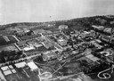
| Description: | Aerial view of the University of Wisconsin campus shows from west to east the Agricultural Hall, Observatory Hall and the Wisconsin Historical Society with... |

| Date: | 1923 |
|---|---|
| Description: | Aerial view of the Wisconsin Historical Society, Science Hall, and Bascom Hall on Bascom Hill on the University of Wisconsin-Madison campus. Lake Mendota i... |
| Date: | 1923 |
|---|---|
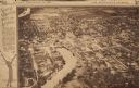
| Description: | Aerial view of town with river. The clipping from a newspaper has a description titled: "Seeing Wisconsin From an Airplane". |
| Date: | 1923 |
|---|---|
| Description: | Elevated view of a bridge over the Black River during construction. It was built during 1923 and 1924 by the Wausau Iron Works. Tom Cleary was the Resident... |
| Date: | 1923 |
|---|---|
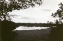
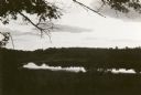
| Description: | View of Fountain Lake (officially known as Ennis Lake), John Muir's boyhood home near Montello. The area is now a 125-acre State Natural Area. Fountain Lak... |
| Date: | 1923 |
|---|---|
| Description: | View of Fountain Lake (officially known as Ennis Lake), John Muir's boyhood home near Montello. The area is now a 125-acre State Natural Area. Fountain Lak... |

| Date: | 1923 |
|---|---|
| Description: | Elevated view of the Milwaukee River from the east bank at the North Avenue dam. Caption on negative reads: "Milwaukee River at North Ave". |

| Date: | 1923 |
|---|---|
| Description: | Firefighters handle a fire hose connected to an International Model G or 61 fire truck operated by the "Canadian Fire Department." |

| Date: | 1923 |
|---|---|
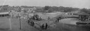
| Description: | Photographic postcard of scenes from Alma. Three scenes from areas around Alma show the town along the Mississippi River, an elevated view of the river bet... |

| Date: | 1923 |
|---|---|
| Description: | This map shows trails, some in red, for automobiles. The right margin includes a key of markings as well as Minnesota and Wisconsin Highway signs. Communit... |

| Date: | 1923 |
|---|---|
| Description: | This early road map shows the system of roads in Wisconsin, northern Illinois, northeastern Iowa, southeastern Minnesota, and the western portion of Michig... |

| Date: | 1923 |
|---|---|
| Description: | A hand-colored map of Marinette County, Wisconsin that shows, townships, towns and plot sections, lakes and streams, cities and villages, and rail lines an... |

| Date: | 1923 |
|---|---|
| Description: | Map showing the parcel of land on the shore of Lake Monona acquired by the City of Madison for a park (today known as Olbrich Park). |

| Date: | 1923 |
|---|---|
| Description: | This map shows counties, roads, Lake Superior, Lake Michigan, and portions of surrounding states. Included is an index to cities, villages and other places... |

| Date: | 1923 |
|---|---|
| Description: | This map includes an explanation that reads: "This chart shows the movement of barley on the Great Lakes, St. Lawrence River, and New York State Barge Cana... |

| Date: | 1923 |
|---|---|
| Description: | This map shows the movement from coalfields in Ohio, Pennsylvania, West Virginia, Kentucky, and part of Virginia to Lake Erie. Quantities of coal are label... |

| Date: | 1923 |
|---|---|
| Description: | This map includes an explanation that reads: "This chart shows the movement of grain on the Great Lakes, St. Lawrence River, and New York State Barge Canal... |

| Date: | 1923 |
|---|---|
| Description: | This map shows the movement of iron ore in areas of Ohio, Pennsylvania, New York, New Jersey, Lake Erie, Lake Ontario, and parts of Ontario, Maryland, and ... |

| Date: | 1923 |
|---|---|
| Description: | This map shows the movement of iron ore in parts of Minnesota, Wisconsin, and the Upper Peninsula of Michigan, and includes parts of Lake Superior, Green B... |
If you didn't find the material you searched for, our Library Reference Staff can help.
Call our reference desk at 608-264-6535 or email us at: