 Filter: Categories of Wisconsin Historical Images
Filter: FULL_DATE of 1923
Filter: Creator Name of Unknown
Filter: Type of Map or Atlas
Filter: Categories of Wisconsin Historical Images
Filter: FULL_DATE of 1923
Filter: Creator Name of Unknown
Filter: Type of Map or Atlas

| Date: | 1923 |
|---|---|
| Description: | Map of Oneida County-Rhinelander Airport which was laid out at the county fairgrounds. The map appears on the reverse side of a letter Roy Larson received ... |

| Date: | 1923 |
|---|---|
| Description: | Vilas County. Published by Chicago, Milwaukee, and St. Paul Ry. |

| Date: | 1923 |
|---|---|
| Description: | This topographical map of Devil's Lake State Park, Sauk County, Wisconsin, is based on 1922-1923 surveys of the area by the University of Wisconsin Summer ... |

| Date: | 1923 |
|---|---|
| Description: | Map showing the parcel of land on the shore of Lake Monona acquired by the City of Madison for a park (today known as Olbrich Park). |

| Date: | 1923 |
|---|---|
| Description: | This manuscript blueprint map shows land parcels regarding the development of the Shorewood community, located on the city side of Lake Mendota. Original c... |
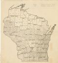
| Date: | 1923 |
|---|---|
| Description: | This map shows the county boundaries, with each dot representing 50 silos. |
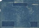
| Date: | 1923 |
|---|---|
| Description: | Blueprint U.S. map showing locations from which reports were received indicating reception of a basketball game broadcast by WHA radio out of Madison. |
If you didn't find the material you searched for, our Library Reference Staff can help.
Call our reference desk at 608-264-6535 or email us at: