Filter: Categories of Wisconsin Historical Images
Filter: FULL_DATE of 1919
Filter: Type of Map or Atlas
Filter: Categories of Wisconsin Historical Images
Filter: FULL_DATE of 1919
Filter: Type of Map or Atlas

| Date: | 1919 |
|---|---|
| Description: | This is a collection of three hand-colored plat maps. One map is a plat plan and includes annotations and an index that shows public land, business, indust... |

| Date: | 1919 |
|---|---|
| Description: | This map depicts the route of the 1842 overland trip by wagon made by the Reverend Alfred Brunson and some copper miners from Prairie du Chien to the mouth... |

| Date: | 1919 |
|---|---|
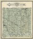
| Description: | This 1919 map of Sawyer County, Wisconsin, shows the township and range system, sections, cities and villages, roads, railroads, farm houses, the Indian re... |
| Date: | 1919 |
|---|---|
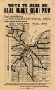
| Description: | This flier, likely printed in 1919, promotes the vote for a bond issue to fund "hard roads" in Brown County, Wisconsin. The map shows the 135 miles of conc... |

| Date: | 1919 |
|---|---|
| Description: | "Map showing the main travelled State and Federal Highways upon which the County Board proposes to expend $1,200,000 for permanent improvements, if you wil... |

| Date: | 1919 |
|---|---|
| Description: | "Map no. 2, Keith and Hiles Lumber Co., Crandon, Wisconsin, Block Map, Block One... Made December 20, 1919. Maker of original map, B. McGinley. Maker of ta... |

| Date: | 1919 |
|---|---|
| Description: | This map is a topographical map and has relief shown by contours. The map shows roads, state highways, hotels, town halls, school houses, stores, barns, de... |

| Date: | 1919 |
|---|---|
| Description: | This map shows details of the harbor, proposed route and bridge changes, railroads, streets, selected buildings, a portion of Lake Superior and other lakes... |

| Date: | 1919 |
|---|---|
| Description: | Narrow red lines show principal secondary highways. Green circles shows points of historical interest. Green triangles show Indian mounds and Indian villag... |

| Date: | 1919 |
|---|---|
| Description: | This map shows auto trails, main roads, rivers, and populations of communities. The map also shows selected hotels and garages and includes a key in the ri... |

| Date: | 1919 |
|---|---|
| Description: | This map contains the automobile routes in southern Wisconsin and northern Illinois. Cities, Lake Winnebago and Green Bay are labeled. The orange print on ... |
If you didn't find the material you searched for, our Library Reference Staff can help.
Call our reference desk at 608-264-6535 or email us at: