 Filter: Categories of Wisconsin Historical Images
Filter: FULL_DATE of 1915
Filter: Subject of water
Filter: Subject of church buildings
Filter: Categories of Wisconsin Historical Images
Filter: FULL_DATE of 1915
Filter: Subject of water
Filter: Subject of church buildings

| Date: | 1915 |
|---|---|
| Description: | Wisconsin Avenue looking toward the northwest from the top of the Capitol. The elevated perspective provides an unusual view of the old City Hall (left) an... |

| Date: | 1915 |
|---|---|
| Description: | Elevated view from the Capitol of South Carroll Street at the corner of West Washington Avenue. |
| Date: | 1915 |
|---|---|
| Description: | The Old Mission Inn by what is believed to be the first Protestant religious building in Wisconsin called Old Mission Congregational Church. |
| Date: | 1915 |
|---|---|
| Description: | The Old Mission Inn by what is believed to be the first Protestant religious building in Wisconsin called Old Mission Congregational Church. |
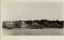
| Date: | 1915 |
|---|---|
| Description: | Nashotah Mission, Lewis Hall. View from a distance with lake in foreground and mission in background. |

| Date: | 1915 |
|---|---|
| Description: | A crowd is gathered on the street as jets of water are being directed by fire fighters towards a fire in a church. |

| Date: | 1915 |
|---|---|
| Description: | This 1915 map of Lincoln County, Wisconsin, shows the township and range grid, towns, cities and villages, lakes and streams, residences, churches, school ... |

| Date: | 1915 |
|---|---|
| Description: | This map of Door County, Wisconsin, from the early 20th century shows roads, schools, churches, creameries and cheese factories, orchards, docks, quarries,... |

| Date: | 1915 |
|---|---|
| Description: | This 1915 map covers the section of the Wisconsin River in southern Adams, southeastern Juneau, northeastern Sauk, and northwestern Columbia counties. A po... |

| Date: | 1915 |
|---|---|
| Description: | This map shows school houses, churches, farms, and railroads. Chequamecon Bay and Bad River Indian Reservation are labeld. The map reads: "All lands shown ... |
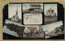
| Date: | 1915 |
|---|---|
| Description: | Six images from Eleva, including two churches, two street scenes, a dwelling and a lake. |
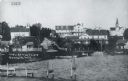
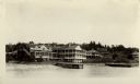
| Date: | 1915 |
|---|---|
| Description: | View of Ephraim from the bay, with a pier in the foreground. Churches are on the left and right, and the Hillside Hotel is in the center near the shore. Ca... |

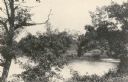
| Date: | 1915 |
|---|---|
| Description: | View of the Upper Dam on the Rock River near Mayville. A church is on the hill on the left. Caption reads: "Upper Dam, Mayville, Wis." |

| Date: | 1915 |
|---|---|
| Description: | A Sanborn fire insurance map of Sauk City created in 1915. |
If you didn't find the material you searched for, our Library Reference Staff can help.
Call our reference desk at 608-264-6535 or email us at: