 Filter: Categories of Wisconsin Historical Images
Filter: FULL_DATE of 1915
Filter: Subject of transportation
Filter: Subject of education
Filter: Categories of Wisconsin Historical Images
Filter: FULL_DATE of 1915
Filter: Subject of transportation
Filter: Subject of education
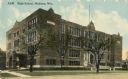
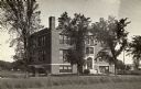
| Date: | 1915 |
|---|---|
| Description: | Central High School, designed by St. Paul architect Cass Gilbert and partially razed in 1986. Caption reads: "High School, Madison, Wis." |
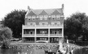
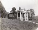
| Date: | 1915 |
|---|---|
| Description: | Exterior front view from Lake Mendota of the Delta Upsilon Fraternity House, located at 640 North Francis Street, erected in 1906. A group of people are o... |
| Date: | 1915 |
|---|---|
| Description: | View from road toward the Public school buildings. Caption reads: "Public School Buildings, Columbus, Wis." |

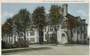
| Date: | 1915 |
|---|---|
| Description: | View from street of the high school. Caption reads: "Garfield Senior High School, Fond du Lac, Wis." |
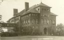
| Date: | 1915 |
|---|---|
| Description: | The Central School, later a part of Stout State College. Caption reads: "Central School, Menomonie, Wis." |
| Date: | 1915 |
|---|---|
| Description: | View from field towards the high school. There is a small group of people sitting on front steps, and an automobile is parked in front on the left. Houses ... |
| Date: | 1915 |
|---|---|
| Description: | Exterior photograph of schoolhouse. Original caption reads: "one room school cost $3786." The building has a stone foundation, a roof vent, and a chimney a... |
| Date: | 1915 |
|---|---|
| Description: | Male and female students from Freedom Academy sit outdoors with two teachers. A larger group sits on platform while a smaller group looks on from the foreg... |

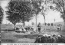
| Date: | 1915 |
|---|---|
| Description: | View down road of horses with horse-drawn carriages parked on the left near what appears to be a park. On the right automobiles are parked along near comme... |

| Date: | 1915 |
|---|---|
| Description: | Agricultural Extension lecturer Dr. F.A. Wolfe carrying an educational chart while riding on horseback along a muddy dirt road. |

| Date: | 1915 |
|---|---|
| Description: | This 1915 map of Lincoln County, Wisconsin, shows the township and range grid, towns, cities and villages, lakes and streams, residences, churches, school ... |

| Date: | 1915 |
|---|---|
| Description: | This map of Door County, Wisconsin, from the early 20th century shows roads, schools, churches, creameries and cheese factories, orchards, docks, quarries,... |

| Date: | 1915 |
|---|---|
| Description: | This 1915 map covers the section of the Wisconsin River in southern Adams, southeastern Juneau, northeastern Sauk, and northwestern Columbia counties. A po... |

| Date: | 1915 |
|---|---|
| Description: | This map shows a plat of city, wards, sections, land ownership by name, local streets, roads, railroads, local businesses, schools, and parks. This map is ... |

| Date: | 1915 |
|---|---|
| Description: | This map shows school houses, churches, farms, and railroads. Chequamecon Bay and Bad River Indian Reservation are labeld. The map reads: "All lands shown ... |

| Date: | 1915 |
|---|---|
| Description: | This map shows roads, railroads, street railways, abandoned logging railroads, rural mail routes, telephone lines, schools, platted land, and state forest ... |
If you didn't find the material you searched for, our Library Reference Staff can help.
Call our reference desk at 608-264-6535 or email us at: