 Filter: Categories of Wisconsin Historical Images
Filter: FULL_DATE of 1915
Filter: Subject of land
Filter: Categories of Wisconsin Historical Images
Filter: FULL_DATE of 1915
Filter: Subject of land

| Date: | 1915 |
|---|---|
| Description: | Plat map of Polk township in Washington County. |

| Date: | 1915 |
|---|---|
| Description: | Plat map of South Germantown in the Township of Germantown sections, 18,19 and 20 from Plat Book of Washington and Ozaukee Counties. |

| Date: | 1915 |
|---|---|
| Description: | A view looking down a tree-lined dirt highway, with an open field on one side and a mountain in the distance. |

| Date: | 1915 |
|---|---|
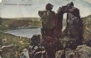
| Description: | Five men in suits pose near the Roaring River in a canyon. |
| Date: | 1915 |
|---|---|
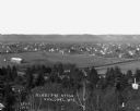
| Description: | Elevated view of the town looking north from Murray Hill. Caption reads: "View of Canaan, N.H., Looking North from Murray Hill." |

| Date: | 1915 |
|---|---|
| Description: | Man plowing a field with a Mogul 8-16 tractor. |
| Date: | 1915 |
|---|---|
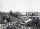
| Description: | A boy standing near a large area of soil erosion in a rural area. |
| Date: | 1915 |
|---|---|
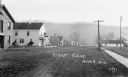
| Description: | View down street of with commercial buildings and dwellings. There are two carriages parked near a building which has part of a sign visible over the entra... |
| Date: | 1915 |
|---|---|
| Description: | Colorized postcard of the rock formation called the Devil's Doorway in Devil's Lake State Park. The lake, bluffs, trees and sky are visible in the backgrou... |
| Date: | 1915 |
|---|---|
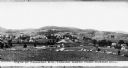
| Description: | View of town. A cemetery is in the foreground and a race track is in the center. |
| Date: | 1915 |
|---|---|
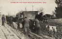
| Description: | Photographic postcard of a man and a woman pushing their automobile through the mud because the wheels are caught in large ruts. Their feet have sunk to th... |

| Date: | 1915 |
|---|---|
| Description: | Side view of a man wearing a straw hat operating a horse-drawn hay rake in a field. In the background are hills, fields and farm buildings. |

| Date: | 1915 |
|---|---|
| Description: | Man operating a horse-drawn hay rake in a field. The horses are wearing fly-nets. There are bales of hay on a hill in the background. |

| Date: | 1915 |
|---|---|
| Description: | A map of Wisconsin that shows 1,900 miles of national highways proposed for the state. The map also includes the names and locations of towns and cities th... |

| Date: | 1915 |
|---|---|
| Description: | Elevated view of an urban main street in the foreground and a rural landscape in the background. |

| Date: | 1915 |
|---|---|
| Description: | A map showing the location of post offices in Wisconsin and Michigan that were in operation as of April, 1915, along with the mail routes in use as well as... |
| Date: | 1915 |
|---|---|
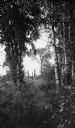
| Description: | Birch and other trees frame the view of a distant house and barn with poplars behind, lining the road (now Highway 42) at Fish Creek. |
| Date: | 1915 |
|---|---|
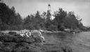
| Description: | Ferdinand Leonard (Fedy) Hotz, far left, sisters Helen, left, and Alice, sit with Thomas Toft on the rocky shore near the Baileys Harbor lighthouse. A rowb... |
If you didn't find the material you searched for, our Library Reference Staff can help.
Call our reference desk at 608-264-6535 or email us at:

