 Filter: Categories of Wisconsin Historical Images
Filter: FULL_DATE of 1915
Filter: Subject of indian reservations
Filter: Categories of Wisconsin Historical Images
Filter: FULL_DATE of 1915
Filter: Subject of indian reservations
| Date: | 1915 |
|---|---|
| Description: | This early 20th century map highlights the land for sale by the American Immigration Company, Chippewa Falls, Wisconsin, in the towns of Cable, Drummond, G... |

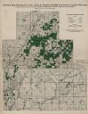
| Date: | 1915 |
|---|---|
| Description: | This map shows school houses, churches, farms, and railroads. Chequamecon Bay and Bad River Indian Reservation are labeld. The map reads: "All lands shown ... |
If you didn't find the material you searched for, our Library Reference Staff can help.
Call our reference desk at 608-264-6535 or email us at: