 Filter: Categories of Wisconsin Historical Images
Filter: FULL_DATE of 1915
Filter: Subject of education
Filter: Categories of Wisconsin Historical Images
Filter: FULL_DATE of 1915
Filter: Subject of education

| Date: | 1915 |
|---|---|
| Description: | Group of school children standing on the steps of a school house(?) holding their bird house projects. |
| Date: | 1915 |
|---|---|
| Description: | Teachers and students using a "Babcock Tester" in a classroom. Original caption reads: "Pupils of grammar grades testing milk with Babcock Tester; County S... |

| Date: | 1915 |
|---|---|
| Description: | View down road of horses with horse-drawn carriages parked on the left near what appears to be a park. On the right automobiles are parked along near comme... |

| Date: | 1915 |
|---|---|
| Description: | Agricultural Extension lecturer Dr. F.A. Wolfe carrying an educational chart while riding on horseback along a muddy dirt road. |
| Date: | 1915 |
|---|---|
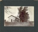
| Description: | A brick, one-story country schoolhouse with two entrances, and an outhouse on the left. The schoolyard is fenced. |
| Date: | 1915 |
|---|---|
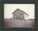
| Description: | A one-story frame country school with a single door. There is a row of trees and a fence on the right. |

| Date: | 1915 |
|---|---|
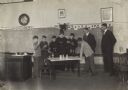
| Description: | Boys use various tools to make fly traps in a classroom. A man, probably their instructor, stands in the background in front of a chalkboard. |

| Date: | 1915 |
|---|---|
| Description: | A group of students and a teacher are sitting at desks in a classroom while listening to a lesson on the dangers of house flies. Agricultural lecture chart... |

| Date: | 1915 |
|---|---|
| Description: | A student is using a pointer to direct the attention of seated students toward a poster labeled "Life Cycle of a Fly" during a lesson on the dangers of hou... |

| Date: | 1915 |
|---|---|
| Description: | This 1915 map of Lincoln County, Wisconsin, shows the township and range grid, towns, cities and villages, lakes and streams, residences, churches, school ... |

| Date: | 1915 |
|---|---|
| Description: | Elevated view, looking north, from the Hotz family compound near the bluff entrance to Fish Creek. Evergreens and bare birch trees stand in the foreground,... |

| Date: | 1915 |
|---|---|
| Description: | This map of Door County, Wisconsin, from the early 20th century shows roads, schools, churches, creameries and cheese factories, orchards, docks, quarries,... |

| Date: | 1915 |
|---|---|
| Description: | This 1915 map covers the section of the Wisconsin River in southern Adams, southeastern Juneau, northeastern Sauk, and northwestern Columbia counties. A po... |
| Date: | 1915 |
|---|---|
| Description: | Exterior view of the public school building and grounds. There is a bell tower above the entrance, and trees are in the yard among tall grass. |

| Date: | 1915 |
|---|---|
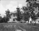
| Description: | View of front and part of left side of the high school. The large brick building features arched windows, a belfry and a flagpole on the roof. |

| Date: | 1915 |
|---|---|
| Description: | Large group of Dairy School students, all men, testing samples in the laboratory. |

| Date: | 1915 |
|---|---|
| Description: | This map shows a plat of city, wards, sections, land ownership by name, local streets, roads, railroads, local businesses, schools, and parks. This map is ... |

| Date: | 1915 |
|---|---|
| Description: | This map shows school houses, churches, farms, and railroads. Chequamecon Bay and Bad River Indian Reservation are labeld. The map reads: "All lands shown ... |

| Date: | 1915 |
|---|---|
| Description: | This map shows roads, railroads, street railways, abandoned logging railroads, rural mail routes, telephone lines, schools, platted land, and state forest ... |
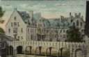
| Date: | 1915 |
|---|---|
| Description: | Elevated view of Grafton Hall. In the foreground is a stone arch covered walkway between two buildings, and a courtyard. Caption reads: "Grafton Hall, Fond... |
If you didn't find the material you searched for, our Library Reference Staff can help.
Call our reference desk at 608-264-6535 or email us at: