Filter: Categories of Wisconsin Historical Images
Filter: FULL_DATE of 1915
Filter: Type of Map or Atlas
Filter: Creator Name of Unknown
Filter: Categories of Wisconsin Historical Images
Filter: FULL_DATE of 1915
Filter: Type of Map or Atlas
Filter: Creator Name of Unknown

| Date: | 1915 |
|---|---|
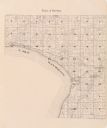
| Description: | Plat map of Polk township in Washington County. |

| Date: | 1915 |
|---|---|
| Description: | This 1915 map covers portions of Barron, Chippewa, and Rusk counties in Wisconsin. Shown are the township and range grid, sections, cities and villages, ra... |

| Date: | 1915 |
|---|---|
| Description: | This map shows school houses, churches, farms, and railroads. Chequamecon Bay and Bad River Indian Reservation are labeld. The map reads: "All lands shown ... |

| Date: | 1915 |
|---|---|
| Description: | This map shows streets and lots with prices available through the Madison Realty Company. Some of the plats include legends. The areas include: Brooks' Add... |

| Date: | 1915 |
|---|---|
| Description: | A composite plat map of the towns of Mequon, Saukville, Belgium, Fort Washington, and Fredonia. |
If you didn't find the material you searched for, our Library Reference Staff can help.
Call our reference desk at 608-264-6535 or email us at: