 Filter: Categories of Wisconsin Historical Images
Filter: FULL_DATE of 1913
Filter: Subject of superior, lake
Filter: Categories of Wisconsin Historical Images
Filter: FULL_DATE of 1913
Filter: Subject of superior, lake
| Date: | 1913 |
|---|---|
| Description: | Elevated view of wooden boats at Raspberry Island (or Devils Island) dock with picnickers on shore. The "Lizzie W' and Nelson Angus, A.G. Hull, Elsie Tough... |
| Date: | 1913 |
|---|---|
| Description: | Mary Baldwin (Duluth), John Neimeyer (Duluth), and the bow of the "Zenya." |

| Date: | 1913 |
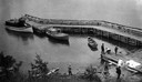
|---|---|
| Description: | Aerial bridge and harbor, with a large boat passing underneath. A lamppost and a beacon are along the walkway towards the bridge on the left. Caption reads... |

| Date: | 1913 |
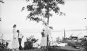
|---|---|
| Description: | Captain Dan Angus standing on wooden boat dock, smoking a cigar. Dr. Albert Gregory Hull is partially visible on the left. The boat dock is possibly on Dev... |
| Date: | 1913 |
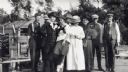
|---|---|
| Description: | Group of men and women standing on a dock at Devils Island. From left to right are Nelson Angus, A.G. Hull, Elsie Tough (Kansas City), Anne Ashley, Mrs. Hu... |
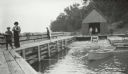
| Date: | 1913 |
|---|---|
| Description: | Boathouse, dock and boat at Devils Island Light Station. Bill Baker, Elsie Tough, and Captain Angus. |

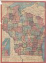
| Date: | 1913 |
|---|---|
| Description: | A hand-colored map of Wisconsin and portions of eastern Iowa and Minnesota, northern Illinois, and the western part of Michigan’s Upper Peninsula, showing ... |
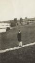
| Date: | 1913 |
|---|---|
| Description: | Jesse Stone walking on board sidewalk, with the Mission Inn along the shoreline in the background. |
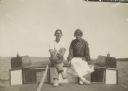
| Date: | 1913 |
|---|---|
| Description: | Two people sitting on a boat. Identified on back as Betty Bishop and Wallace? Wallace is wearing a baseball mitt on his left hand. |
| Date: | 1913 |
|---|---|
| Description: | This map shows automobile roads, cities, county boundaries, rivers, lakes, railroads, electric lines, and congressional districts. Included are portions of... |

| Date: | 1913 |
|---|---|
| Description: | This map details automobile routes throughout the state and parts of Illinois, Minnesota, Michigan, and Iowa. Cities, counties, Lake Michigan, Lake Superio... |

| Date: | 1913 |
|---|---|
| Description: | This map displays automobile routes across Wisconsin as well as Minnesota, Iowa, Michigan and Illinois. Cities, counties, Lake Michigan, Lake Superior, Gre... |
If you didn't find the material you searched for, our Library Reference Staff can help.
Call our reference desk at 608-264-6535 or email us at: