 Filter: Categories of Wisconsin Historical Images
Filter: FULL_DATE of 1912
Filter: Subject of indians of north america
Filter: Categories of Wisconsin Historical Images
Filter: FULL_DATE of 1912
Filter: Subject of indians of north america
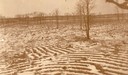
| Date: | 1912 |
|---|---|
| Description: | Indian cultivated garden beds, partially covered with snow, "South of West over the big area." Now known as the Eulrich Site, a mile from the shore of Lake... |
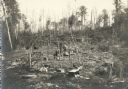
| Date: | 1912 |
|---|---|
| Description: | Vilas County, Ricing camp, Rice Creek. Lac Du Flambeau area. |
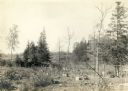
| Date: | 1912 |
|---|---|
| Description: | Vilas County, Ricing camp, Rice Creek. Lac Du Flambeau area. |
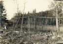
| Date: | 1912 |
|---|---|
| Description: | Vilas County, Ricing camp, Rice Creek. Lac Du Flambeau area. |
| Date: | 1912 |
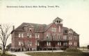
|---|---|
| Description: | Exterior view of the main building. Caption reads: "Government Indian School, Main Building, Tomah, Wis." |
| Date: | 1912 |
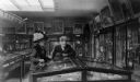
|---|---|
| Description: | Well-dressed Julia and Julius Jacobson looking at Indian artifacts at the State Historical Society of Wisconsin Museum during their wedding trip to Madison... |
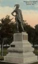
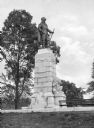
| Date: | 1912 |
|---|---|
| Description: | Statue of Chief Oshkosh of the Menominee Tribe. Sculpted by Trentanove and located in Menominee Park. The statue honors the man who gave his name to the ci... |
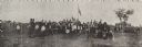
| Date: | 1912 |
|---|---|
| Description: | Panoramic image of Chippewa (Ojibwa) Indians at a fair in northern Wisconsin. Caption under the image reads, "Souvenier [sic] of Odanah, Fair 1913."... |

| Date: | 1912 |
|---|---|
| Description: | Full-length studio portrait of a young Ho-Chunk man posing in front of a painted backdrop. Benjamin Raymond Thundercloud (NySaGaShiskKah), son of Annie Blo... |
| Date: | 1912 |
|---|---|
| Description: | Statue dedicated to the French geographer, explorer and colonialist Samuel de Champlain (1567-1635). A bronze man in a cape stands at the top of the pedes... |

| Date: | 1912 |
|---|---|
| Description: | This map from the U.S. General Land Office shows railroads, counties, cities and villages, rivers, lakes, U.S. Land Offices, Indian reservations, military ... |

| Date: | 1912 |
|---|---|
| Description: | This map shows a school reserve, swamp land, railroads, and selected buildings. |
If you didn't find the material you searched for, our Library Reference Staff can help.
Call our reference desk at 608-264-6535 or email us at: