 Filter: Categories of Wisconsin Historical Images
Filter: FULL_DATE of 1911
Filter: Subject of indian reservations
Filter: Categories of Wisconsin Historical Images
Filter: FULL_DATE of 1911
Filter: Subject of indian reservations
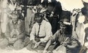
| Date: | 1911 |
|---|---|
| Description: | Indians playing a game at Lac du Flambeau, Wisconsin. "The man in the center is holding counting sticks. A constant drumming is kept up to make concentra... |

| Date: | 1911 |
|---|---|
| Description: | This 1911 map of the geology of northern Wisconsin between Superior and Hurley was published by the Wisconsin Geological and Natural History Survey in Fred... |

| Date: | 1911 |
|---|---|
| Description: | This map shows swamps, railroads, rivers, roads, the Catholic Mission Reserve, the day school, and the Agency Reserve. Lake Superior is labeled. An inset m... |

| Date: | 1911 |
|---|---|
| Description: | This map shows lakes, rivers, swamps, state swamp land, trails and railroads. Includes a township diagram. |

| Date: | 1911 |
|---|---|
| Description: | This map shows railroads, roads, swamps, a school site and farm, and a mill site. The map includes a "typical township" diagram. Lac du Flambeau, Long Lake... |
If you didn't find the material you searched for, our Library Reference Staff can help.
Call our reference desk at 608-264-6535 or email us at: