 Filter: Categories of Wisconsin Historical Images
Filter: FULL_DATE of 1911
Filter: Subject of human settlements
Filter: Categories of Wisconsin Historical Images
Filter: FULL_DATE of 1911
Filter: Subject of human settlements
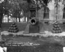
| Date: | 1911 |
|---|---|
| Description: | A decommissioned Civil War cannon at Courthouse Park. |

| Date: | 1911 |
|---|---|
| Description: | Exterior of the Methodist Evangelical Church. A small boy sits on the curb along the cobblestone street outside the building. Next door to the church is Ho... |

| Date: | 1911 |
|---|---|
| Description: | View down street towards the exterior of the Catholic Church, where a horse is tied to a tree nearby. |

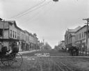
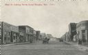
| Date: | 1911 |
|---|---|
| Description: | View down brick paved Main Street. A horse and carriage travels along the street. Caption reads: "Scene on Main St., Mauston, Wis." |
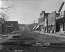
| Date: | 1911 |
|---|---|
| Description: | View down an unpaved street in the business district. The buildings along the street include: a pool room, restaurant, opera house, W.G. Baxter's dry goods... |
| Date: | 1911 |
|---|---|
| Description: | View down street lined with businesses. There is a surrey or carriage with fringe along the top in the foreground on the left, and two women sit in a horse... |
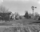
| Date: | 1911 |
|---|---|
| Description: | View down unpaved street. A group of men and boys congregate on the porch of a storefront. Two men and two children stand in the street. There is a windmil... |
| Date: | 1911 |
|---|---|
| Description: | Black and white postcard of Main Street, looking north. A horse-drawn wagon is traveling north and another is parked on the right. On the left is a store, ... |

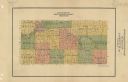
| Date: | 1911 |
|---|---|
| Description: | This map of Wisconsin, the western portion of Michigan's Upper Peninsula, and northern Illinois shows counties, towns, cities and villages, rivers and lake... |

| Date: | 1911 |
|---|---|
| Description: | View across water of trees and wooden buildings submerged in water, probably during the 1911 (or 1905) flood of the Black River. |

| Date: | 1911 |
|---|---|
| Description: | A delivery truck with the store name: "Knox-Romig Furniture Co." is parked in front of the Knox-Romig storefront. There is a covered piece of furniture, pr... |

| Date: | 1911 |
|---|---|
| Description: | A map of the Racine, Kenosha, and portions of Milwaukee counties, that shows the townships in Racine and Kenosha, and the townships of Brookfield, New Berl... |

| Date: | 1911 |
|---|---|
| Description: | This map of Polk County, Wisconsin, from the early 20th century shows the land for sale by the Baker Land and Title Co. of Saint Croix Falls. The township ... |

| Date: | 1911 |
|---|---|
| Description: | This 1911 map shows the Post Office's rural routes in Racine County, Wisconsin, and portions of eastern Walworth and northern Kenosha counties. The locatio... |

| Date: | 1911 |
|---|---|
| Description: | This 1911 map of south central Sawyer County, Wisconsin, shows land for sale by Veness & Kasl of Exeland, the township and range system, sections, homes, r... |

| Date: | 1911 |
|---|---|
| Description: | This map, taken from the 1911 Map of Wisconsin showing geology and roads by Hotchkiss and Thwaites, shows the northwest portion of Douglas County, Wisconsi... |

| Date: | 1911 |
|---|---|
| Description: | This 1911 map of the geology of northern Wisconsin between Superior and Hurley was published by the Wisconsin Geological and Natural History Survey in Fred... |
| Date: | 1911 |
|---|---|
| Description: | Map shows townships and sections, roads, and railroads. "W.W. Downs, attorney-at-law, Eau Claire, Wis." |

| Date: | 1911 |
|---|---|
| Description: | This 1911 map from the U.S. Post Office Dept. shows rural delivery routes, active and discontinued post offices, selected rural landowners and houses, chur... |

| Date: | 1911 |
|---|---|
| Description: | This 1911 map from the U.S. Post Office Dept. shows rural delivery routes, active and discontinued post offices, collection boxes, selected rural landowner... |
If you didn't find the material you searched for, our Library Reference Staff can help.
Call our reference desk at 608-264-6535 or email us at: