Filter: Categories of Wisconsin Historical Images
Filter: FULL_DATE of 1911
Filter: Subject of formations (geology)
Filter: Categories of Wisconsin Historical Images
Filter: FULL_DATE of 1911
Filter: Subject of formations (geology)
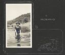
| Date: | 1911 |
|---|---|
| Description: | Delia Drew King wades in Lake Flora Dell. There is a hill and shoreline in the background, and a group of people stands near a pier behind Delia. A hand-dr... |
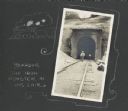
| Date: | 1911 |
|---|---|
| Description: | Frank Drew walks a set of railroad tracks near the entrance into a tunnel. The other end of the tunnel can be seen in the distance. A hand-drawn border fea... |
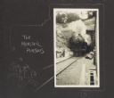
| Date: | 1911 |
|---|---|
| Description: | Front view of train emerging from a tunnel. A hand-drawn border features two male figures running away from the train and reads, "The monster pursues." |

| Date: | 1911 |
|---|---|
| Description: | View of workers in a large quarry in Ableman. Several male workers are standing in the quarry among piles of rock with their work equipment. |

| Date: | 1911 |
|---|---|
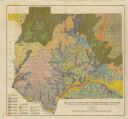
| Description: | This map, taken from the 1911 Map of Wisconsin showing geology and roads by Hotchkiss and Thwaites, shows the northwest portion of Douglas County, Wisconsi... |

| Date: | 1911 |
|---|---|
| Description: | This 1911 map of the geology of northern Wisconsin between Superior and Hurley was published by the Wisconsin Geological and Natural History Survey in Fred... |

| Date: | 1911 |
|---|---|
| Description: | This map shows the soil types of towns and counties. A key of soil types is included with yellow, blue, brown, pink, orange, green, and gray. The top left ... |
| Date: | 1911 |
|---|---|
| Description: | This map shows soil types of towns and counties. A key of 14 soil types is included. The top left margin reads: "Wisconsin Geological and Natural History S... |
| Date: | 1911 |
|---|---|
| Description: | This map shows soil types, lakes, rivers, and railroads. A key of soil profiles and a legend of soil types is included. The bottom margin reads: "Soils su... |
| Date: | 1911 |
|---|---|
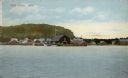
| Description: | Hand-colored view of Fish Creek from the bay. A boathouse and main dock are in the center. A bluff is in the background. Caption reads: "Fish Creek, Wis." |

| Date: | 1911 |
|---|---|
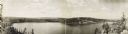
| Description: | A panoramic view of the Namakan River created by piecing two photographs together. |

| Date: | 1911 |
|---|---|
| Description: | The dramatic shoreline of the Namakan River, featuring eroded land and tall trees. The canoes are on the shoreline. |

| Date: | 1911 |
|---|---|
| Description: | View across water towards a large rock outcropping on Rainy Lake. |

| Date: | 1911 |
|---|---|
| Description: | View of the Country Club and grounds. Bluffs are in the background. Caption reads: "The La Crosse Country Club, La Crosse, Wis." |
If you didn't find the material you searched for, our Library Reference Staff can help.
Call our reference desk at 608-264-6535 or email us at: