 Filter: Categories of Wisconsin Historical Images
Filter: FULL_DATE of 1910
Filter: Subject of maps
Filter: Categories of Wisconsin Historical Images
Filter: FULL_DATE of 1910
Filter: Subject of maps

| Date: | 1910 |
|---|---|
| Description: | Aerial view of some of the 26 lakes known collectively as the Chain O' Lakes. Caption reads: "Aeroplane View of Chain O'Lakes, Waupaca, Wis." |

| Date: | 1910 |
|---|---|
| Description: | Advertising poster for Osborne brand agricultural equipment produced by International Harvester for Russia. Features a map of Russia with inset color illus... |

| Date: | 1910 |
|---|---|
| Description: | Advertising poster for Plano brand agricultural machinery produced by International Harvester for Russia. Features a map of Russia with inset color illustr... |

| Date: | 1910 |
|---|---|
| Description: | This map of shows railway lines in red, with railroad land grant in Taylor, Price, and Ashland Counties shaded red, on top of the cities, counties, highway... |

| Date: | 1910 |
|---|---|
| Description: | This map shows the Soo Line railroad and Arpin Hardwood Lumber Company lands in red. The top margin of the map reads: "Wisconsin, the safest state in the U... |

| Date: | 1910 |
|---|---|
| Description: | This set of manuscript blueprint maps show block and lot numbers, railroads, and some landownership, including lands and buildings of J.S. Owen Lumber Co. ... |

| Date: | 1910 |
|---|---|
| Description: | This map shows automobile routes across the state as well as Minnesota, Iowa, Illinois, and Michigan. Cities, Lake Michigan, Lake Superior, the Mississippi... |
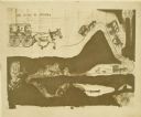
| Date: | 1910 |
|---|---|
| Description: | Carl Greene's drawing of a map of The Gang's trip to Winton, titled "We drive to Winton." This map shows a road currently known as the Thirteen Corners Roa... |

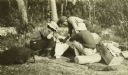
| Date: | 1910 |
|---|---|
| Description: | Fred Carr and Bill Marr reading a map together while sitting on the ground. |
| Date: | 1910 |
|---|---|
| Description: | The Gang is sitting on their packs or bedrolls as they consult their maps with a ranger. |

| Date: | 1910 |
|---|---|
| Description: | Bank interior. On the left is a roll-top desk. There is a sign for "Cashier" on the wall in the center at the barred window. A framed certificate below it ... |
If you didn't find the material you searched for, our Library Reference Staff can help.
Call our reference desk at 608-264-6535 or email us at: