 Filter: Categories of Wisconsin Historical Images
Filter: FULL_DATE of 1908
Filter: Year of 1900-1999
Filter: Subject of transportation
Filter: Community of Madison
Filter: Categories of Wisconsin Historical Images
Filter: FULL_DATE of 1908
Filter: Year of 1900-1999
Filter: Subject of transportation
Filter: Community of Madison

| Date: | 1908 |
|---|---|
| Description: | Aerial view of Camp Randall Field on the University of Wisconsin-Madison campus. University Heights is in the background. |

| Date: | 1908 |
|---|---|
| Description: | Colored map showing a panoramic view of Madison in great detail. The Wisconsin State Capitol is located at the center, with Lake Mendota in the background ... |

| Date: | 1908 |
|---|---|
| Description: | A panoramic aerial view of the Isthmus taken from a kite. Lake Mendota is to the right in the background with Picnic Point jutting into the lake. The photo... |

| Date: | 1908 |
|---|---|
| Description: | Drawing of the general design for future construction development at the University of Wisconsin with the Barn, Sheep Barn, Horse Barn, House, Power House,... |

| Date: | 1908 |
|---|---|
| Description: | General design for future construction development of the University of Madison campus with the general view of the campus by the Architectural commission. |
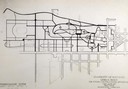
| Date: | 1908 |
|---|---|
| Description: | Drawing of the general design for future constructional development of the thoroughfare system on the University of Wisconsin campus by the Architectural C... |
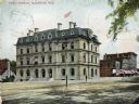
| Date: | 1908 |
|---|---|
| Description: | Colorized view of the U.S. Post Office and its surrounding streets. Caption reads: "Post Office, Madison, Wis." |
| Date: | 1908 |
|---|---|
| Description: | Joseph Pearson, milkman, poses with his wagon and team of horses in front of the Madison High School at the corner of Wisconsin Avenue and Johnson Street. |

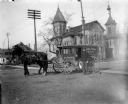
| Date: | 1908 |
|---|---|
| Description: | Dane County Telephone Co. horse-drawn service and installation wagon. The Wisconsin State Capitol is in the background. “Dad” Schroeder and Oscar Quale are... |

| Date: | 1908 |
|---|---|
| Description: | A detail of a Sanborn map showing the area around North Franklin, North Blair and North Hancock Streets. |

| Date: | 1908 |
|---|---|
| Description: | Watercolor painting of a canoe and sailboat on Lake Mendota. In the background is the city skyline on the far shoreline. |
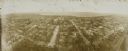
| Date: | 1908 |
|---|---|
| Description: | Kite aerial panoramic photograph of the central business district. In the distance is Lake Mendota. The fire damaged Wisconsin State Capitol is in the cent... |

| Date: | 1908 |
|---|---|
| Description: | Hand-colored postcard of the water tower near the corner of Pinckney Street and East Washington Avenue. Horse-drawn vehicles are in the street, and pedestr... |

| Date: | 1908 |
|---|---|
| Description: | Bird's-eye view showing Lake Mendota, Lake Monona, Lake Waubesa, Lake Wingra and Lake Kegonsa. Madison has only the isthmus developed, and there are settle... |

| Date: | 1908 |
|---|---|
| Description: | View towards the corner of West Washington Avenue and Carroll Street. Church buildings are on the right. Caption reads: "West Washington Avenue from Capito... |

| Date: | 1908 |
|---|---|
| Description: | A Sanborn map including a portion of the East Johnson Street and East Gorham Street neighborhood. |
If you didn't find the material you searched for, our Library Reference Staff can help.
Call our reference desk at 608-264-6535 or email us at: