 Filter: Categories of Wisconsin Historical Images
Filter: FULL_DATE of 1907
Filter: Subject of cities and towns
Filter: Subject of transportation
Filter: Categories of Wisconsin Historical Images
Filter: FULL_DATE of 1907
Filter: Subject of cities and towns
Filter: Subject of transportation

| Date: | 1907 |
|---|---|
| Description: | Colorized postcard view from street of the Catholic Church and Parsonage on a tree-lined street in a residential neighborhood. Caption reads: "Catholic Chu... |
| Date: | 1907 |
|---|---|
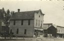
| Description: | Photographic postcard view across street towards the Herman Smith Saloon storefront, with a man and two dogs on the sidewalk in front. A horse and buggy ar... |
| Date: | 1907 |
|---|---|
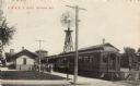
| Description: | Photographic postcard view of the depot and train with passengers on the platform. A large windmill is in the background. Caption reads: "C. M. & St. P. De... |

| Date: | 1907 |
|---|---|
| Description: | This map of Superior and the vicinity shows selected company properties, railroads, and roads in a portion of Douglas County. The map reads: "Copyrighted 1... |

| Date: | 1907 |
|---|---|
| Description: | Photographic postcard of the Thompson Tent Show. Two tents, a tall wagon, an automobile and a truck are set up in a field or park with houses and trees in ... |

| Date: | 1907 |
|---|---|
| Description: | Photographic postcard of the Thompson Tent Show. A tent, a tall wagon and a truck that runs the generator are set up in a field or park with houses and tre... |
| Date: | 1907 |
|---|---|
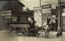
| Description: | A horse-drawn cart, marked B.C. Horsch, is waiting near Dr. W.H. Perrigo's veterinary and dental business in the S. Sixth Street neighborhood in Milwaukee.... |

| Date: | 1907 |
|---|---|
| Description: | View from street towards the high school. Caption reads: "High School, Clintonville, Wis." |

| Date: | 1907 |
|---|---|
| Description: | View from Ludington Street of houses along a sidewalk. Trees are planted along the terrace. Caption reads: "Ludington Street, Columbus, Wis." |

| Date: | 1907 |
|---|---|
| Description: | This map is a chart of Milwaukee Harbor that displays local streets, bridges, roads, railroads, public buildings, businesses, factories, dry docks, parks, ... |

| Date: | 1907 |
|---|---|
| Description: | This map shows ward numbers, streets, railroads, electric car lines, parks, steam railways, section numbers, Lake Michigan and one mile concentric circles ... |

| Date: | 1907 |
|---|---|
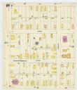
| Description: | Sanborn map of Green Bay including St. George and Main Streets. |

| Date: | 1907 |
|---|---|
| Description: | Sanborn map of Green Bay featuring Elm, Cedar and Main Streets. |
| Date: | 1907 |
|---|---|
| Description: | Sanborn map of Green Bay, including Harvey, Willow and Plesant Streets. |

| Date: | 1907 |
|---|---|
| Description: | This manuscript blueprint map shows land parcels pertaining to University Heights region in Madison, Wisconsin. Streets labeled included, University Avenue... |

| Date: | 1907 |
|---|---|
| Description: | This blueprint map shows a proposed plan for pleasure roads and reservation system. It also shows schools, cemeteries, old river channel, proposed bridge, ... |
| Date: | 1907 |
|---|---|
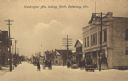
| Description: | View of Washington Avenue on a snowy day. The A.F. Bruss Building is on the right. Horse-drawn carts and sleighs are in the street. Caption reads: "Washing... |
| Date: | 1907 |
|---|---|
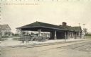
| Description: | Hand-colored view of the train station. Two carts and a man are standing on the platform. Railroad tracks are in the foreground, and houses are in the back... |
| Date: | 1907 |
|---|---|
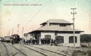
| Description: | Hand-colored view down railroad tracks toward the substation. An interurban car is on the railroad tracks, and a group of passengers are on the platform. C... |

| Date: | 1907 |
|---|---|
| Description: | Photographic postcard view looking down the center of Main Street towards a group of children standing in a row in the center of the street. There is a hor... |
If you didn't find the material you searched for, our Library Reference Staff can help.
Call our reference desk at 608-264-6535 or email us at: