 Filter: Categories of Wisconsin Historical Images
Filter: FULL_DATE of 1906
Filter: Subject of transportation
Filter: Categories of Wisconsin Historical Images
Filter: FULL_DATE of 1906
Filter: Subject of transportation

| Date: | 1906 |
|---|---|
| Description: | Two men, two women, and a boy are posing sitting in an automobile parked in the yard next to a frame house. Probably Eugene J. Greenlee and son Eugene in t... |

| Date: | 1906 |
|---|---|
| Description: | A hand-colored commercial map of Wisconsin and portions of eastern Minnesota, Iowa, northern Illinois, and the Michigan’s Upper Peninsula. The map shows ra... |

| Date: | 1906 |
|---|---|
| Description: | A map of Berlin, Wisconsin and the surrounding area, showing the old channel of the Fox River and the site of Mascouten village just south of that city in ... |

| Date: | 1906 |
|---|---|
| Description: | View across water of an excursion steamboat on the Mississippi River. This image is a part of Frank Feiker's 'Souvenir' series. |
| Date: | 1906 |
|---|---|
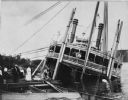
| Description: | Group of people stand on pier near the Diamond Jo line steamboat Quincy, sunk in 1906. It was raised and renamed the J.S. There are men on th... |

| Date: | 1906 |
|---|---|
| Description: | This map of Sheboygan County, Wisconsin, from the early 20th century shows school districts and school locations in the county. Also shown are the township... |

| Date: | 1906 |
|---|---|
| Description: | Hand-colored postcard view of the Sturgeon Bay ship canal from the bay toward shore. A sailboat is on the left and a lighthouse is on shore on the right. C... |

| Date: | 1906 |
|---|---|
| Description: | This 1906 map of Bayfield County, Wisconsin, shows towns, sections, cities, villages and post offices, land ownership, wagon roads, railroads, schools, gov... |
| Date: | 1906 |
|---|---|
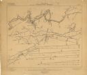
| Description: | These maps, which are based on a 1906 survey, show the Wisconsin River from Sugar Bowl Rock, approximately 2 1/2 miles below Wisconsin Dells (labeled Kilbo... |

| Date: | 1906 |
|---|---|
| Description: | Shows railroads, lakes, rivers, cities, and boundaries of zones. "For the Wisconsin Central Railroad Co." Includes longitudial section, 3 cross sections, a... |
| Date: | 1906 |
|---|---|
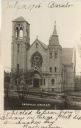
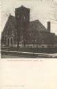
| Description: | Photographic postcard of an elevated view across street of the front of the Catholic Church, which is a large, stone building. There is a belfry on the lef... |
| Date: | 1906 |
|---|---|
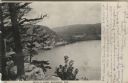
| Description: | View from bluff of Devil's Lake. A road runs along the far shoreline. Caption reads: "Devil's Lake, Baraboo, Wis." |
| Date: | 1906 |
|---|---|
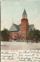
| Description: | Colorized postcard of an exterior view of City Hall, a brick building with an arched entrance, a flag pole on the left, and a belfry on the right. Caption ... |
| Date: | 1906 |
|---|---|
| Description: | Colorized postcard view of the exterior of the Second Congregational Church. Caption reads: "Second Congregational Church, Beloit, Wis." |

| Date: | 1906 |
|---|---|
| Description: | Colorized postcard view of a lock on the Fox River. Caption reads: "The Locks, Berlin, Wis." |
| Date: | 1906 |
|---|---|
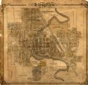
| Description: | This map of Stoughton shows plat additions, numbered lots, some land ownership, and labeled streets. The map is color coded in blue, pink, and yellow altho... |
| Date: | 1906 |
|---|---|
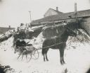
| Description: | Winter scene with a man and woman driving in a horse-drawn "cutter" in the snow. They have a fur blanket over their laps. Behind them is a building, perhap... |
| Date: | 1906 |
|---|---|
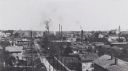
| Description: | Elevated view of town with homes and factories. |
| Date: | 1906 |
|---|---|
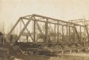
| Description: | Steel span railroad bridge under construction over Cedar Creek. |
| Date: | 1906 |
|---|---|
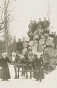
| Description: | Horse-drawn load of 6000 ft. of pine logs, accompanied by a cornet player and two women, at the Weinkauf & Co. timber lands. |
If you didn't find the material you searched for, our Library Reference Staff can help.
Call our reference desk at 608-264-6535 or email us at: