 Filter: Categories of Wisconsin Historical Images
Filter: FULL_DATE of 1906
Filter: Subject of cities and towns
Filter: Categories of Wisconsin Historical Images
Filter: FULL_DATE of 1906
Filter: Subject of cities and towns

| Date: | 1906 |
|---|---|
| Description: | View from edge of road of dairy building on the University of Wisconsin-Madison campus. A stone and timber, Queen Anne-style structure of wood beams and st... |
| Date: | 1906 |
|---|---|
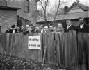
| Description: | A group of adults, including Harry E. Cole (center), stand behind a fence. A sign on the fence reads, "YOU CAN'T PLAY IN OUR BACK YARD." |
| Date: | 1906 |
|---|---|
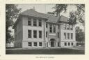
| Description: | Exterior view of the Doty School, 351 West Wilson Street, Madison, with the caption "The New Doty School." |
| Date: | 1906 |
|---|---|
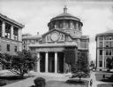
| Description: | Slightly elevated view of St. Paul's Chapel and the surrounding buildings. The structure features a Classical-style porch, columns, pediment, and dome. Arc... |

| Date: | 1906 |
|---|---|
| Description: | View from rocky shoreline of a lumber mill on the banks of the Chippewa River. Smoke is coming out from a smokestack. |
| Date: | 1906 |
|---|---|
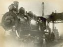
| Description: | Five railroad employees pose on Chicago, Milwaukee & St. Paul Railway engine no. 1223 at the Chestnut Street yard. Left to right are yardman Jack Meyer, ya... |

| Date: | 1906 |
|---|---|
| Description: | Rear elevation of the West Cottage Hillside Home School, the school run by Ellen and Jane Lloyd Jones, aunts of architect Frank Lloyd Wright. In 1902 Wrigh... |
| Date: | 1906 |
|---|---|
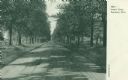
| Description: | View looking down tree-lined Lovers' Lane. Caption reads: "Lovers' Lane, Appleton, Wis." |
| Date: | 1906 |
|---|---|
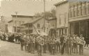
| Description: | Brass marching band in uniforms and spectators at a Memorial Day parade. The band and spectators stand in the road outside city shops and business, includi... |

| Date: | 1906 |
|---|---|
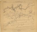
| Description: | Hand-drawn topographical map of the Turville Estate. |

| Date: | 1906 |
|---|---|
| Description: | Topographical map of Turville Point and lands to the South to Nine Springs Creek. |

| Date: | 1906 |
|---|---|
| Description: | C.N. Oulie Jewelry Store located at 9 Main Street. Sign reflected in the window advertises the Wisconsin State Fair, September 10-14, 1906. |

| Date: | 1906 |
|---|---|
| Description: | A hand-colored map of Wisconsin identifying the railroads, counties, cities, rivers, and lakes in Wisconsin, eastern Minnesota and Iowa, northern Illinois,... |

| Date: | 1906 |
|---|---|
| Description: | A hand-colored commercial map of Wisconsin and portions of eastern Minnesota, Iowa, northern Illinois, and the Michigan’s Upper Peninsula. The map shows ra... |

| Date: | 1906 |
|---|---|
| Description: | A commercial map of Wisconsin showing the location of creameries and cheese factories in the state. In the lower portion of the map provides the number of ... |

| Date: | 1906 |
|---|---|
| Description: | A map of Berlin, Wisconsin and the surrounding area, showing the old channel of the Fox River and the site of Mascouten village just south of that city in ... |

| Date: | 1906 |
|---|---|
| Description: | This map of Sheboygan County, Wisconsin, from the early 20th century shows school districts and school locations in the county. Also shown are the township... |

| Date: | 1906 |
|---|---|
| Description: | This 1906 map of Bayfield County, Wisconsin, shows towns, sections, cities, villages and post offices, land ownership, wagon roads, railroads, schools, gov... |

| Date: | 1906 |
|---|---|
| Description: | This map, which shows the Fox River and the likely location of a Mascoutin village near Berlin, Wisconsin, was published in the Proceedings of the State Hi... |
| Date: | 1906 |
|---|---|
| Description: | These maps, which are based on a 1906 survey, show the Wisconsin River from Sugar Bowl Rock, approximately 2 1/2 miles below Wisconsin Dells (labeled Kilbo... |
If you didn't find the material you searched for, our Library Reference Staff can help.
Call our reference desk at 608-264-6535 or email us at: