 Filter: Categories of Wisconsin Historical Images
Filter: FULL_DATE of 1906
Filter: Reproduction Rights of For Sale
Filter: Categories of Wisconsin Historical Images
Filter: FULL_DATE of 1906
Filter: Reproduction Rights of For Sale

| Date: | 1906 |
|---|---|
| Description: | Interior of Cecil W. Smith's room at Hillside Home School showing his desk and work table. |
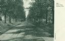
| Date: | 1906 |
|---|---|
| Description: | View looking down tree-lined Lovers' Lane. Caption reads: "Lovers' Lane, Appleton, Wis." |
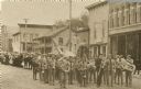
| Date: | 1906 |
|---|---|
| Description: | Brass marching band in uniforms and spectators at a Memorial Day parade. The band and spectators stand in the road outside city shops and business, includi... |

| Date: | 1906 |
|---|---|
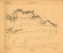
| Description: | Hand-drawn topographical map of the Turville Estate. |

| Date: | 1906 |
|---|---|
| Description: | Topographical map of Turville Point and lands to the South to Nine Springs Creek. |
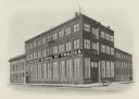
| Date: | 1906 |
|---|---|
| Description: | An exterior view of the Milwaukee School of Trades. |

| Date: | 1906 |
|---|---|
| Description: | C.N. Oulie Jewelry Store located at 9 Main Street. Sign reflected in the window advertises the Wisconsin State Fair, September 10-14, 1906. |

| Date: | 1906 |
|---|---|
| Description: | Schlitz advertisement copied from the "Milwaukee Press Club Annual." The image features an African man holding a Schlitz advertising sign. Underneath the i... |

| Date: | 1906 |
|---|---|
| Description: | A hand-colored map of Wisconsin identifying the railroads, counties, cities, rivers, and lakes in Wisconsin, eastern Minnesota and Iowa, northern Illinois,... |

| Date: | 1906 |
|---|---|
| Description: | Two men, two women, and a boy are posing sitting in an automobile parked in the yard next to a frame house. Probably Eugene J. Greenlee and son Eugene in t... |

| Date: | 1906 |
|---|---|
| Description: | A hand-colored commercial map of Wisconsin and portions of eastern Minnesota, Iowa, northern Illinois, and the Michigan’s Upper Peninsula. The map shows ra... |

| Date: | 1906 |
|---|---|
| Description: | A commercial map of Wisconsin showing the location of creameries and cheese factories in the state. In the lower portion of the map provides the number of ... |

| Date: | 1906 |
|---|---|
| Description: | Full-length studio portrait of a young woman standing in front of a painted backdrop. She is wearing a dark dress, hair bow and shoes. A crucifix is hangin... |

| Date: | 1906 |
|---|---|
| Description: | A map of Berlin, Wisconsin and the surrounding area, showing the old channel of the Fox River and the site of Mascouten village just south of that city in ... |

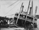
| Date: | 1906 |
|---|---|
| Description: | View across water of an excursion steamboat on the Mississippi River. This image is a part of Frank Feiker's 'Souvenir' series. |
| Date: | 1906 |
|---|---|
| Description: | Group of people stand on pier near the Diamond Jo line steamboat Quincy, sunk in 1906. It was raised and renamed the J.S. There are men on th... |

| Date: | 1906 |
|---|---|
| Description: | This map of Sheboygan County, Wisconsin, from the early 20th century shows school districts and school locations in the county. Also shown are the township... |

| Date: | 1906 |
|---|---|
| Description: | Hand-colored postcard view of the Sturgeon Bay ship canal from the bay toward shore. A sailboat is on the left and a lighthouse is on shore on the right. C... |

| Date: | 1906 |
|---|---|
| Description: | This 1906 map of Bayfield County, Wisconsin, shows towns, sections, cities, villages and post offices, land ownership, wagon roads, railroads, schools, gov... |
| Date: | 1906 |
|---|---|
| Description: | Portion of title: Eau Claire River, Wisconsin. Relief shown by contours and spot heights. Contour interval on land 5 feet. Contour interval on river surfac... |
If you didn't find the material you searched for, our Library Reference Staff can help.
Call our reference desk at 608-264-6535 or email us at: