 Filter: Categories of Wisconsin Historical Images
Filter: FULL_DATE of 1903
Filter: Subject of lakes
Filter: Categories of Wisconsin Historical Images
Filter: FULL_DATE of 1903
Filter: Subject of lakes
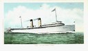
| Date: | 1903 |
|---|---|
| Description: | The screw passenger cruise vessel, North West, underway. |
| Date: | 1903 |
|---|---|
| Description: | View from Lake Mendota of house at 630 N. Lake Street. Robert C. Spencer, architect. The Armory and University of Wisconsin-Madison Boathouse are behind an... |

| Date: | 1903 |
|---|---|
| Description: | A map of northern Wisconsin and Michigan showing the names and locations hunting and fishing resorts in the area, as well as location of Chicago and North ... |

| Date: | 1903 |
|---|---|
| Description: | A map that shows the location of each county, city and village in Wisconsin; in addition that maps also identifies railroads their distances between cities... |

| Date: | 1903 |
|---|---|
| Description: | This 1903 map of Outagamie County, Wisconsin, shows the township and range grid, towns, sections, cities and villages, landownership and acreages, rural ma... |

| Date: | 1903 |
|---|---|
| Description: | Map of Brown County, Wisconsin, shows the township and range grid, towns, sections, cities, villages and post offices, land owners and acreages, railroads,... |

| Date: | 1903 |
|---|---|
| Description: | This map is ink on printed paper reading: "standard profile plate." "Surveyed Oct. 15, platted Dec. 15, 1903 ; surveyed May 9, platted Dec. 9." |

| Date: | 1903 |
|---|---|
| Description: | This map shows lakes, rivers, railroads, and the soil types of towns and counties. A legend of soil types and conventional signs is included. Relief is sho... |

| Date: | 1903 |
|---|---|
| Description: | This map shows lakes, roads, railroads, townships, and land ownership by name. Counties are colored red, blue, or yellow. Lake Michigan is labeled. Also in... |

| Date: | 1903 |
|---|---|
| Description: | This map shows townships and sections, landownership and acreages, roads, railroads, and selected rural buildings. Townships and sections appear in yellow,... |
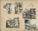
| Date: | 1903 |
|---|---|
| Description: | An album page comprises five photographic prints and a watercolor painting of a shooting star (Dodecatheon) flower. The photograph at lower right was taken... |
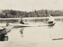
| Date: | 1903 |
|---|---|
| Description: | Helen Pool and James McClure are sitting in a canoe on Archibald Lake. McClure is holding a paddle. On the left is the pier. In the foreground, on the righ... |
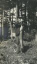
| Date: | 1903 |
|---|---|
| Description: | Rev. John Robertson Macartney is holding a freshly caught pickeral on a stringer. Maiden Lake is in the background. Page heading reads: "Rev. J. Robertson ... |
If you didn't find the material you searched for, our Library Reference Staff can help.
Call our reference desk at 608-264-6535 or email us at: