 Filter: Categories of Wisconsin Historical Images
Filter: FULL_DATE of 1902
Filter: Subject of streams
Filter: Categories of Wisconsin Historical Images
Filter: FULL_DATE of 1902
Filter: Subject of streams

| Date: | 1902 |
|---|---|
| Description: | This 1902 map of the eastern portion of Sawyer County, Wisconsin, shows the township and range system, sections, roads, farm houses, camps, school houses, ... |

| Date: | 1902 |
|---|---|
| Description: | This 1902 map of Winnebago County, Wisconsin, shows the township and range grid, towns, sections, cities and villages, landownership and acreages, railroad... |

| Date: | 1902 |
|---|---|
| Description: | This 1902 map of Chippewa County, Wisconsin, shows the township and range grid, towns, sections, cities, villages and post offices, land ownership and acre... |
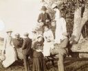
| Date: | 1902 |
|---|---|
| Description: | A group of young men and women are visiting McCauslin Brook. Standing on the tree trunk, W.A. Holt is holding a paper lantern. The woman, standing next to ... |
If you didn't find the material you searched for, our Library Reference Staff can help.
Call our reference desk at 608-264-6535 or email us at: