 Filter: Categories of Wisconsin Historical Images
Filter: FULL_DATE of 1902
Filter: Subject of lakes
Filter: Categories of Wisconsin Historical Images
Filter: FULL_DATE of 1902
Filter: Subject of lakes
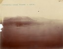
| Date: | 1902 |
|---|---|
| Description: | One of several pyramid rock formations from which the lake takes its name. |
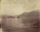
| Date: | 1902 |
|---|---|
| Description: | A distant view of Pyramid Lake's Rattlesnake Island. |
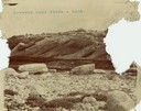
| Date: | 1902 |
|---|---|
| Description: | A rock formation on Pyramid Lake's Rattlesnake Island. |

| Date: | 1902 |
|---|---|
| Description: | This map shows the railroads of southern Wisconsin with the routes of the Chicago, Milwaukee, and St. Paul Railway traced in red. The township grid, counti... |

| Date: | 1902 |
|---|---|
| Description: | This 1902 map of the eastern portion of Sawyer County, Wisconsin, shows the township and range system, sections, roads, farm houses, camps, school houses, ... |
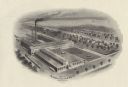
| Date: | 1902 |
|---|---|
| Description: | A bird's-eye view illustration of the Northern Electrical Manufacturing Company. The company was founded in 1895 by four Madison businessmen, Conrad M. Con... |

| Date: | 1902 |
|---|---|
| Description: | This 1902 map of Winnebago County, Wisconsin, shows the township and range grid, towns, sections, cities and villages, landownership and acreages, railroad... |

| Date: | 1902 |
|---|---|
| Description: | This 1902 map of Chippewa County, Wisconsin, shows the township and range grid, towns, sections, cities, villages and post offices, land ownership and acre... |
| Date: | 1902 |
|---|---|
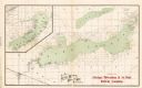
| Description: | A map of Lake Geneva and Lake Delavan, also including Lake Como. |
| Date: | 1902 |
|---|---|
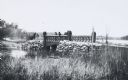
| Description: | Scene along “Willow Drive,” later known as "University Drive," on the shore of Lake Mendota, showing the neo-Gothic carved bridge. View from shoreline of t... |

| Date: | 1902 |
|---|---|
| Description: | Madison Sanborn map, including Langdon and State Streets. |

| Date: | 1902 |
|---|---|
| Description: | This map includes six diagrams of the Great Lakes Region comparing advantages of geographical positions and strategic considerations. Portions of Iowa, Ill... |

| Date: | 1902 |
|---|---|
| Description: | This map shows lakes, railroads, and rivers. Also includes an explanation of railroad lines and mileage, information on state institutions, normal schools,... |

| Date: | 1902 |
|---|---|
| Description: | This blueprint map shows land parcels, parks, blocks, and streets in the region north to Atwood Avenue, south to Lake Monona, west to Evergreen Avenue, and... |

| Date: | 1902 |
|---|---|
| Description: | This map shows townships, land parcels, schools, rivers, lakes, creameries, churches, cemeteries, roads, post offices, town halls, saw mills, roads and sto... |

| Date: | 1902 |
|---|---|
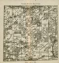
| Description: | A plat map of Lincoln County showing Township 34 North, Range 8 East. |
| Date: | 1902 |
|---|---|
| Description: | A plat map of a portion of Lincoln County, showing Township 35 North, Range 8 East. |
| Date: | 1902 |
|---|---|
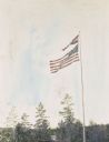
| Description: | An American flag and Islander flag flying on a flag pole at the island. Trees and Archibald Lake are in the background. Caption reads: "Long may it ... |

| Date: | 1902 |
|---|---|
| Description: | A close-up of Wallace Rumsey rowing on Archibald Lake. Photo album page heading reads: "The recreations of Uncle Wallace." |
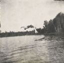
| Date: | 1902 |
|---|---|
| Description: | Wallace Donelson Rumsey, the photographer's younger brother, is doing a back flip dive off a raft into Archibald Lake. He was named after Civil War General... |
If you didn't find the material you searched for, our Library Reference Staff can help.
Call our reference desk at 608-264-6535 or email us at: