Filter: Categories of Wisconsin Historical Images
Filter: FULL_DATE of 1900
Filter: Community of Green Bay
Filter: Categories of Wisconsin Historical Images
Filter: FULL_DATE of 1900
Filter: Community of Green Bay
| Date: | 1900 |
|---|---|
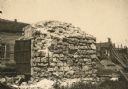
| Description: | View of the Astor Bank vault, built by John Jacob Astor in Green Bay. |

| Date: | 1900 |
|---|---|
| Description: | W.W. Cargill Company's grain elevator. |

| Date: | 1900 |
|---|---|
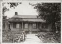
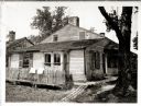
| Description: | George Green's house, located at 904 South Monroe Street. The house was built in 1896. |
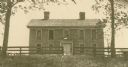
| Date: | 1900 |
|---|---|
| Description: | David Grignon's house, built by Judge Lawe in 1832, burned 1903. |
| Date: | 1900 |
|---|---|
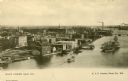
| Description: | Looking North. Harbor with boats, bridge, and buildings. |
| Date: | 1900 |
|---|---|
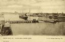
| Description: | Elevated view of east Green Bay harbor with cargo ships, W.W. Cagill Co., and other various industries. |
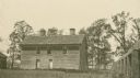
| Date: | 1900 |
|---|---|
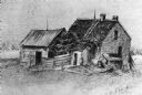
| Description: | Jourdain's homestead, built by Joseph Jourdain in what was then Ft. Howard, Wisconsin. Eleazer Williams is said to have married Joseph Jourdain's daughter ... |
| Date: | 1900 |
|---|---|
| Description: | Exterior view of the Tank cottage before restoration, located on its original site on the west side of the Fox River. The cottage was built in 1776 by Jose... |
| Date: | 1900 |
|---|---|
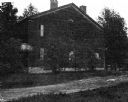
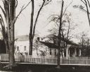
| Description: | View from across street of the Whitney House. A man stands in the yard behind the fence. There are large trees along the curb, and more trees and shrubs in... |

| Date: | 1900 |
|---|---|
| Description: | This map of Green Bay shows plat of the town, lots by number, local streets, the military Fort Howard, part of Fox River and part of Navarino. The map feat... |

| Date: | 1900 |
|---|---|
| Description: | This photostat of a manuscript map originally drawn in 1829 shows landownership, buildings, including Fort Howard and U.S. sawmill, swamps, public barns an... |

| Date: | 1900 |
|---|---|
| Description: | This photostat map shows private claim owners, natural meadows, roads, saw and grist mills, and Fort Howard. The upper right corner includes annotations an... |

| Date: | 1900 |
|---|---|
| Description: | This photostat map was probably originally created in 1835 and shows in addition to private claims, mills, roads, and trails. Green Bay and the Fox River a... |

| Date: | 1900 |
|---|---|
| Description: | This photocopied map shows private claim owners, buildings, and land use in 1818. Insets show Fort Howard and the caption reads: "A view of the Fox River ... |
If you didn't find the material you searched for, our Library Reference Staff can help.
Call our reference desk at 608-264-6535 or email us at: