 Filter: Categories of Wisconsin Historical Images
Filter: FULL_DATE of 1899
Filter: Subject of lakes
Filter: Categories of Wisconsin Historical Images
Filter: FULL_DATE of 1899
Filter: Subject of lakes
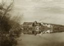
| Date: | 1899 |
|---|---|
| Description: | View along shoreline of University of Wisconsin-Madison buildings across Lake Mendota from Carroll Street. The Armory (Red Gym or Old Red), a boathouse, an... |
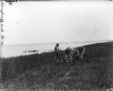
| Date: | 1899 |
|---|---|
| Description: | A farmer is standing next to a mower pulled by two oxen in a field next to a lake. |
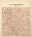
| Date: | 1899 |
|---|---|
| Description: | Plat map of Blooming Grove Township in Dane County. |

| Date: | 1899 |
|---|---|
| Description: | This color map, originally published in the Smithsonian Institution Bureau of American Ethnology's 18th annual report, shows the Indian land cessions in Wi... |

| Date: | 1899 |
|---|---|
| Description: | This 1899 map shows the contour depths of Big Cedar Lake in Washington County, Wisconsin, and includes four cross sections of the lake. Roads, railroads, s... |

| Date: | 1899 |
|---|---|
| Description: | These two maps of Madison and the Four Lakes region show the site of the Teachers Country Club on Lake Monona, the lakes and the Catfish or Yahara River, f... |

| Date: | 1899 |
|---|---|
| Description: | This 1899 map of Dodge County, Wisconsin, shows the township and range grid, towns, sections, cities and villages, roads, railroads, post offices, cemeteri... |

| Date: | 1899 |
|---|---|
| Description: | A plat map of the township of Westport. |

| Date: | 1899 |
|---|---|
| Description: | Elizabeth Turvill Wood on the beach with two puppies, who are investigating a dead fish. The lake is in the background. |

| Date: | 1899 |
|---|---|
| Description: | A plat map showing Lake Monona, the isthmus in Madison, and the towns of Burke and Blooming Grove. |

| Date: | 1899 |
|---|---|
| Description: | A map of the west part of the city of Madison, including University Heights and the Capitol Square. |

| Date: | 1899 |
|---|---|
| Description: | A map of the east part of the city of Madison, including a portion of the isthmus. |
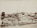
| Date: | 1899 |
|---|---|
| Description: | Elevated view looking west over the open basements of commercial buildings which were destroyed by a recent fire. Main Street is in the foreground. Horse-d... |

| Date: | 1899 |
|---|---|
| Description: | This map shows color coded and numbered regions of Indian land cessions. Lake Superior and Lake Michigan are labeled and other lakes and rivers are shown. ... |

| Date: | 1899 |
|---|---|
| Description: | This map shows color coded and numbered regions of Indian land cessions. Lake Superior and Lake Michigan are labeled and other lakes and rivers are shown. ... |
| Date: | 1899 |
|---|---|
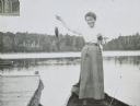
| Description: | Annie McClure is standing in a boat showing the fish she caught on Archibald Lake. There is a pier on the left, and a tree-lined shore is in the background... |
| Date: | 1899 |
|---|---|
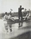
| Description: | A foursome is boating on Archibald Lake. William Leonard Burnap, standing up in the boat, is wringing water out of something with his hands. The man sittin... |
| Date: | 1899 |
|---|---|
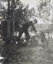
| Description: | Wallace Rumsey is building a wooden seat from a fallen log at Lookout Point on the Island at Archibald Lake. Caption reads: "Building the seat on the point... |
| Date: | 1899 |
|---|---|
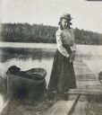
| Description: | Jeannie Schauers is standing on wooden planks near a pier on the shoreline of Archibald Lake. A rowboat is pulled up on the shoreline on the left. |

| Date: | 1899 |
|---|---|
| Description: | A plat map of Pleasant Springs in Dane County. |
If you didn't find the material you searched for, our Library Reference Staff can help.
Call our reference desk at 608-264-6535 or email us at: