Filter: Categories of Wisconsin Historical Images
Filter: FULL_DATE of 1899
Filter: Subject of human settlements
Filter: Categories of Wisconsin Historical Images
Filter: FULL_DATE of 1899
Filter: Subject of human settlements

| Date: | 1899 |
|---|---|
| Description: | This map shows color coded and numbered regions of Indian land cessions. Lake Superior and Lake Michigan are labeled and other lakes and rivers are shown. ... |

| Date: | 1899 |
|---|---|
| Description: | This map shows color coded and numbered regions of Indian land cessions. Lake Superior and Lake Michigan are labeled and other lakes and rivers are shown. ... |
| Date: | 1899 |
|---|---|
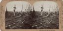
| Description: | Stereograph of the devastation caused by a tornado. All that remains of trees are the main branches and trunks, some with building debris caught in them. P... |

| Date: | 1899 |
|---|---|
| Description: | Stereograph of President McKinley speaking to a large crowd from a stage decorated with bunting. In the background are buildings and train cars. Caption re... |
| Date: | 1899 |
|---|---|
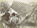
| Description: | Shaded by a striped canopy, three women are sitting together and smiling in the Holt family backyard. Wearing aprons, the woman on the left and the woman w... |

| Date: | 1899 |
|---|---|
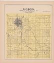
| Description: | A plat map of Burke, Cottage Grove, McFarland, Waunakee, Quarry Town, Klevenville, and Vilas. |

| Date: | 1899 |
|---|---|
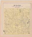
| Description: | A plat map of Pleasant Springs in Dane County. |

| Date: | 1899 |
|---|---|
| Description: | Three men posing with their bicycles along a picket fence. Caption reads: "On Camp Randall, 1899. Bicycle Team." The name "Sumner" is written in the lower ... |

| Date: | 1899 |
|---|---|
| Description: | A plat map of the township of Christiana. |
If you didn't find the material you searched for, our Library Reference Staff can help.
Call our reference desk at 608-264-6535 or email us at: