 Filter: Categories of Wisconsin Historical Images
Filter: FULL_DATE of 1899
Filter: Creator Name of Unknown
Filter: Subject of transportation
Filter: Categories of Wisconsin Historical Images
Filter: FULL_DATE of 1899
Filter: Creator Name of Unknown
Filter: Subject of transportation
| Date: | 1899 |
|---|---|
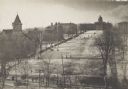
| Description: | Elevated view of Bascom Hill and lower campus vicinity from the roof of the Wisconsin Historical Society, which was then under construction. A large group ... |
| Date: | 1899 |
|---|---|
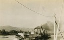
| Description: | The Clyde after being converted to a sternwheel rafter, pushing a tow with a locomotive on board. |
| Date: | 1899 |
|---|---|
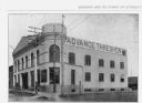
| Description: | Exterior view of the Advance Thresher Company, 601 Williamson Street, as seen in "Madison, Wis. And It's Points Of Interest." The dealer was one of many wh... |
| Date: | 1899 |
|---|---|
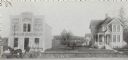
| Description: | The Smith M. Jacobs Flour and Feed Store (left) and residence (right), 301 and 303 Monroe Street. The address renumbered within the next five years to 1701... |
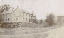
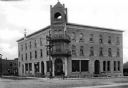
| Date: | 1899 |
|---|---|
| Description: | Allen's hotel. A horse-drawn vehicle is in front of the hotel. |
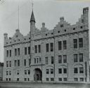
| Date: | 1899 |
|---|---|
| Description: | Front of armory on Broadway Street, which has a single turret and a sign that reads "Light Horse Squadron Armory." Housed the Light Squadron of the Wiscons... |
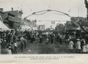
| Date: | 1899 |
|---|---|
| Description: | View of a marching band parading beneath a decorated arch on Main Street. Onlookers line both sides of the street. American flags are flying over the road ... |
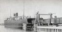
| Date: | 1899 |
|---|---|
| Description: | Chicago, St. Paul, Minneapolis & Omaha train cars loading onto car ferry Pere Marquette. |
| Date: | 1899 |
|---|---|
| Description: | View of Hotel Hutchinson, situated at the corner of two streets. The entrance stands beneath a bell tower and a group of boys, some with bicycles, stands n... |
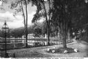
| Date: | 1899 |
|---|---|
| Description: | A man steers a horse and carriage down a winding country road near Clarendon Pond. Village dwellings are visible across the pond. |

| Date: | 1899 |
|---|---|
| Description: | Overhead map of the Stanley McCormick's Riven Rock estate in El Montecito, Santa Barbara, California. The map shows the placement of dwellings and fields, ... |

| Date: | 1899 |
|---|---|
| Description: | A map showing the shoreline of a portion of El Montecito, Santa Barbara County, California. The map shows properties along the Pacific Ocean, and may have ... |
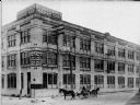
| Date: | 1899 |
|---|---|
| Description: | Exterior view of the building at the corner of N. 12th St. and W. St. Paul Avenue that housed Badger State Shoe Co. and Saveland Manufacturing Co. Two hors... |

| Date: | 1899 |
|---|---|
| Description: | These two maps of Madison and the Four Lakes region show the site of the Teachers Country Club on Lake Monona, the lakes and the Catfish or Yahara River, f... |

| Date: | 1899 |
|---|---|
| Description: | This map is a folded insert from the pamphlet "Yesterday and Today : A History." The map features the North-Western Line with labeled railway tracks and st... |

| Date: | 1899 |
|---|---|
| Description: | This map shows parks, block numbers, Lake Michigan, and railroads. Relief is shown by contours. Also included is an explanation that lists how many miles o... |

| Date: | 1899 |
|---|---|
| Description: | A plat map showing Lake Monona, the isthmus in Madison, and the towns of Burke and Blooming Grove. |

| Date: | 1899 |
|---|---|
| Description: | A plat map of Burke, Cottage Grove, McFarland, Waunakee, Quarry Town, Klevenville, and Vilas. |
If you didn't find the material you searched for, our Library Reference Staff can help.
Call our reference desk at 608-264-6535 or email us at:

