 Filter: Categories of Wisconsin Historical Images
Filter: FULL_DATE of 1899
Filter: Type of Map or Atlas
Filter: Subject of lakes
Filter: Categories of Wisconsin Historical Images
Filter: FULL_DATE of 1899
Filter: Type of Map or Atlas
Filter: Subject of lakes
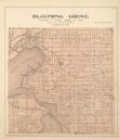
| Date: | 1899 |
|---|---|
| Description: | Plat map of Blooming Grove Township in Dane County. |

| Date: | 1899 |
|---|---|
| Description: | This color map, originally published in the Smithsonian Institution Bureau of American Ethnology's 18th annual report, shows the Indian land cessions in Wi... |

| Date: | 1899 |
|---|---|
| Description: | This 1899 map shows the contour depths of Big Cedar Lake in Washington County, Wisconsin, and includes four cross sections of the lake. Roads, railroads, s... |

| Date: | 1899 |
|---|---|
| Description: | These two maps of Madison and the Four Lakes region show the site of the Teachers Country Club on Lake Monona, the lakes and the Catfish or Yahara River, f... |

| Date: | 1899 |
|---|---|
| Description: | This 1899 map of Dodge County, Wisconsin, shows the township and range grid, towns, sections, cities and villages, roads, railroads, post offices, cemeteri... |

| Date: | 1899 |
|---|---|
| Description: | A plat map of the township of Westport. |

| Date: | 1899 |
|---|---|
| Description: | A plat map showing Lake Monona, the isthmus in Madison, and the towns of Burke and Blooming Grove. |

| Date: | 1899 |
|---|---|
| Description: | A map of the west part of the city of Madison, including University Heights and the Capitol Square. |

| Date: | 1899 |
|---|---|
| Description: | A map of the east part of the city of Madison, including a portion of the isthmus. |

| Date: | 1899 |
|---|---|
| Description: | This map shows color coded and numbered regions of Indian land cessions. Lake Superior and Lake Michigan are labeled and other lakes and rivers are shown. ... |

| Date: | 1899 |
|---|---|
| Description: | This map shows color coded and numbered regions of Indian land cessions. Lake Superior and Lake Michigan are labeled and other lakes and rivers are shown. ... |

| Date: | 1899 |
|---|---|
| Description: | A plat map of Pleasant Springs in Dane County. |

| Date: | 1899 |
|---|---|
| Description: | A plat map of the township of Christiana. |
If you didn't find the material you searched for, our Library Reference Staff can help.
Call our reference desk at 608-264-6535 or email us at:

