 Filter: Categories of Wisconsin Historical Images
Filter: FULL_DATE of 1896
Filter: Categories of Wisconsin Historical Images
Filter: FULL_DATE of 1896

| Date: | 1896 |
|---|---|
| Description: | This hand-colored map shows counties, county seats, cities, towns, proposed and completed railroads, and U.S. Land Offices. Also included in the map are th... |

| Date: | 1896 |
|---|---|
| Description: | A map showing the Wisconsin Central Railroad lines in Wisconsin, northern Illinois, eastern Minnesota, and Michigan’s Upper Peninsula. The area of the map ... |
| Date: | 1896 |
|---|---|
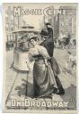
| Description: | Black and white lithograph poster. Caption at top reads “Maggie Cline" with image of Cline at a Broadway intersection crossing a trolley track while a poli... |

| Date: | 1896 |
|---|---|
| Description: | Color lithograph poster for "The War of Wealth." In the picture, a crowd of adults is surrounding a child, one man reaching to grab the girl's hand. At the... |

| Date: | 1896 |
|---|---|
| Description: | Color lithograph poster. An Afgan prisoner with chains on his wrists fires a cannon past a man and a woman prisoner in it while a mob gathers outside the p... |
| Date: | 1896 |
|---|---|
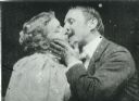
| Description: | A frame enlargement from Thomas Edison's 1896 silent film "The Kiss" featuring May Irwin and John C. Rice reprising the controversial final scene of the pl... |
| Date: | 1896 |
|---|---|
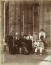
| Description: | Group portrait including Violet Lee Dousman (back row, 4th from left) and her fellow travelers on a trip to Egypt. |
| Date: | 1896 |
|---|---|
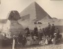
| Description: | A group portrait of Violet Lee Dousman (back row, 3rd from left) and her fellow travelers, guides and Egyptians on a trip to Giza, Egypt. Five people are r... |

| Date: | 1896 |
|---|---|
| Description: | A map of Green Lake County, Wisconsin, shows township divisions, villages and post offices, railroads, roads, lakes and streams, schools, and churches. |

| Date: | 1896 |
|---|---|
| Description: | A map of Iron County, Wisconsin, shows vacant Wisconsin Central Rail Road lands, settlers houses, land sold by Wisconsin Central R.R., schools, churches, s... |

| Date: | 1896 |
|---|---|
| Description: | A hand-colored Map of Jefferson County, Wisconsin, shows township and section divisions, towns, villages and post offices, rural residents, railroads, road... |
| Date: | 1896 |
|---|---|
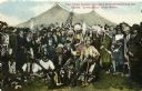
| Description: | Colored postcard view of "Buffalo Bill" Cody center right in white coat and hat surrounded by Native Americans in traditional garb, military personnel and ... |

| Date: | 1896 |
|---|---|
| Description: | A map of Marinette County, Wisconsin that shows the sectioning of townships and other plots, towns, cities and villages, lakes and streams, railroads, and... |

| Date: | 1896 |
|---|---|
| Description: | A map of Milwaukee County, Wisconsin that shows the township and range system, sections, towns, roads, railroads and rail stations, cities and villages, po... |

| Date: | 1896 |
|---|---|
| Description: | This 1896 map shows the township and range system, sections, cities and villages, railroads, vacant land and land sold by the Wisconsin Central Railroad, s... |

| Date: | 1896 |
|---|---|
| Description: | This 1896 map of Racine and Kenosha counties, Wisconsin, shows the township and range grid, towns, sections, cities, villages and post offices, roads, rail... |

| Date: | 1896 |
|---|---|
| Description: | This 1896 map shows the township and range system, sections, cities and villages, railroads, roads, vacant land and land sold by the Wisconsin Central Rail... |

| Date: | 1896 |
|---|---|
| Description: | This 1898 map shows the township and range system, sections, cities and villages, railroads, roads, vacant land and land sold by the Wisconsin Central Rail... |

| Date: | 1896 |
|---|---|
| Description: | This late 19th century map of Walworth County, Wisconsin, shows the township and range grid, towns, sections, villages and post offices, roads, railroads, ... |
If you didn't find the material you searched for, our Library Reference Staff can help.
Call our reference desk at 608-264-6535 or email us at:
