 Filter: Categories of Wisconsin Historical Images
Filter: FULL_DATE of 1896
Filter: Subject of water
Filter: Subject of lakes
Filter: Categories of Wisconsin Historical Images
Filter: FULL_DATE of 1896
Filter: Subject of water
Filter: Subject of lakes
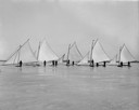
| Date: | 1896 |
|---|---|
| Description: | A gathering of iceboats and their captains on Lake Mendota. |

| Date: | 1896 |
|---|---|
| Description: | A portion of John B. Heim's map of the Water Works System of Madison showing the size of the third Wisconsin Capitol (228' x 226') in comparison with the C... |

| Date: | 1896 |
|---|---|
| Description: | Map showing the Wisconsin Central Railroad and its land grant, with the railroad and the land grant in color (red). |
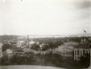
| Date: | 1896 |
|---|---|
| Description: | View from the Wisconsin State Capitol dome looking west towards Bascom Hill. Mifflin street with City Hall and the Fuller Opera House are in the foreground... |
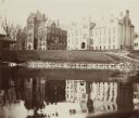
| Date: | 1896 |
|---|---|
| Description: | View over water of Science Hall and the Chemical Laboratory on the University of Wisconsin-Madison campus, as seen from a boat in Lake Mendota. Part of a b... |
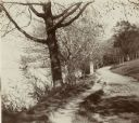
| Date: | 1896 |
|---|---|
| Description: | Looking down University of Wisconsin Drive (present-day Lakeshore Path). Large trees grows along the shoreline on the left, and on the right is a thick woo... |

| Date: | 1896 |
|---|---|
| Description: | Mrs. Elsie Stevens poses on a path by a lake while riding a horse. Possibly on the University of Wisconsin-Madison drive (present-day Lakeshore path). |

| Date: | 1896 |
|---|---|
| Description: | Section 2 of 12, this bicycle road map features Wisconsin bicycle routes in the counties of Marquette, Green Lake, Columbia, Fond Du Lac, Dodge, Washington... |

| Date: | 1896 |
|---|---|
| Description: | Section 5 of 12, this bicycle road map features Wisconsin bicycle routes in the counties of La Crosse, Monroe, Vernon, Crawford, Richland, Sauk, Juneau, an... |

| Date: | 1896 |
|---|---|
| Description: | A map of the Chain-O-Lakes in Waupaca, including Indian trails. The path of the Waupaca Electric Railway from the Grand View Hotel to the Wisconsin Central... |

| Date: | 1896 |
|---|---|
| Description: | This hand-colored map shows counties, county seats, cities, towns, proposed and completed railroads, and U.S. Land Offices. Also included in the map are th... |

| Date: | 1896 |
|---|---|
| Description: | A map showing the Wisconsin Central Railroad lines in Wisconsin, northern Illinois, eastern Minnesota, and Michigan’s Upper Peninsula. The area of the map ... |

| Date: | 1896 |
|---|---|
| Description: | A map of Green Lake County, Wisconsin, shows township divisions, villages and post offices, railroads, roads, lakes and streams, schools, and churches. |

| Date: | 1896 |
|---|---|
| Description: | A hand-colored Map of Jefferson County, Wisconsin, shows township and section divisions, towns, villages and post offices, rural residents, railroads, road... |

| Date: | 1896 |
|---|---|
| Description: | A map of Marinette County, Wisconsin that shows the sectioning of townships and other plots, towns, cities and villages, lakes and streams, railroads, and... |

| Date: | 1896 |
|---|---|
| Description: | This 1896 map shows the township and range system, sections, cities and villages, railroads, vacant land and land sold by the Wisconsin Central Railroad, s... |

| Date: | 1896 |
|---|---|
| Description: | This 1896 map of Racine and Kenosha counties, Wisconsin, shows the township and range grid, towns, sections, cities, villages and post offices, roads, rail... |

| Date: | 1896 |
|---|---|
| Description: | This 1896 map shows the township and range system, sections, cities and villages, railroads, roads, vacant land and land sold by the Wisconsin Central Rail... |

| Date: | 1896 |
|---|---|
| Description: | This 1898 map shows the township and range system, sections, cities and villages, railroads, roads, vacant land and land sold by the Wisconsin Central Rail... |
If you didn't find the material you searched for, our Library Reference Staff can help.
Call our reference desk at 608-264-6535 or email us at:
