 Filter: Categories of Wisconsin Historical Images
Filter: FULL_DATE of 1896
Filter: Subject of recreation areas
Filter: Categories of Wisconsin Historical Images
Filter: FULL_DATE of 1896
Filter: Subject of recreation areas
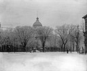
| Date: | 1896 |
|---|---|
| Description: | Winter scene of the third Wisconsin State Capitol looking west from King Street. By the turn of the century, the trees in the Capitol had grown tall and on... |

| Date: | 1896 |
|---|---|
| Description: | Bird's-eye map of Fond du Lac, looking north west, with two insets of the P.H. Stamm residence, and the Proposed Lakeside Park. thirty-five locations ident... |

| Date: | 1896 |
|---|---|
| Description: | A portion of John B. Heim's map of the Water Works System of Madison showing the size of the third Wisconsin Capitol (228' x 226') in comparison with the C... |

| Date: | 1896 |
|---|---|
| Description: | Map highlighting parks and other points of interest in Milwaukee. |

| Date: | 1896 |
|---|---|
| Description: | This map shows streets, wards, railroads, parks, cemeteries, and Lake Michigan. Also included are explanations and an index of points of interest. |
If you didn't find the material you searched for, our Library Reference Staff can help.
Call our reference desk at 608-264-6535 or email us at: