Filter: Categories of Wisconsin Historical Images
Filter: FULL_DATE of 1896
Filter: Subject of land
Filter: Categories of Wisconsin Historical Images
Filter: FULL_DATE of 1896
Filter: Subject of land
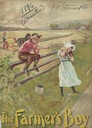
| Date: | 1896 |
|---|---|
| Description: | Cover of an advertising catalog for the Milwaukee Harvester Company, featuring a color chromolithograph illustration of a young boy and girl playing along ... |

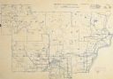
| Date: | 1896 |
|---|---|
| Description: | Bird's-eye map of Darlington. Area bordered by Washington and North Streets, upper left hand corner, the fairgrounds, upper right corner, River Street, bot... |

| Date: | 1896 |
|---|---|
| Description: | A portion of John B. Heim's map of the Water Works System of Madison showing the size of the third Wisconsin Capitol (228' x 226') in comparison with the C... |
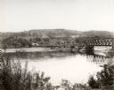
| Date: | 1896 |
|---|---|
| Description: | Elevated view. Caption on negative sleeve reads: "Black Hawk Battlefield. Wis. Heights. 'Looking it of west across river' [sic] c. 1896. Mrs. Charle... |
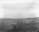
| Date: | 1896 |
|---|---|
| Description: | Elevated view. Caption on negative sleeve reads: "Black Hawk Battlefield. Wis. Heights. Looking N. of E. up valley towards Catholic Church. Mrs. Charles N.... |
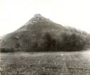
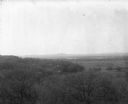
| Date: | 1896 |
|---|---|
| Description: | View of Black Hawk Bluff, site of the Battle of Wisconsin Heights in the Black Hawk War. |

| Date: | 1896 |
|---|---|
| Description: | Map showing the Wisconsin Central Railroad and its land grant, with the railroad and the land grant in color (red). |
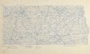
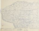
| Date: | 1896 |
|---|---|
| Description: | Section 1 of 12, this bicycle road map features Wisconsin bicycle routes in the counties of Dane, Jefferson, Waukesha, Milwaukee, Green, Rock, Walworth, Ra... |
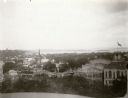
| Date: | 1896 |
|---|---|
| Description: | View from the Wisconsin State Capitol dome looking west towards Bascom Hill. Mifflin street with City Hall and the Fuller Opera House are in the foreground... |

| Date: | 1896 |
|---|---|
| Description: | Elevated panoramic view of a section of the Wisconsin Dells and the Wisconsin River visible from the "Sliding Rock." In the lower left hand corner the word... |
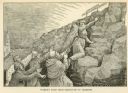
| Date: | 1896 |
|---|---|
| Description: | Illustration from the Freethinkers Pictorial Text Book of a woman climbing a steep, rocky slope to a sign that reads "Come Up Higher / The Free Thou... |

| Date: | 1896 |
|---|---|
| Description: | Section 2 of 12, this bicycle road map features Wisconsin bicycle routes in the counties of Marquette, Green Lake, Columbia, Fond Du Lac, Dodge, Washington... |
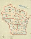
| Date: | 1896 |
|---|---|
| Description: | This map shows 12 sections of bicycle road maps. Sections and number are in red, counties are in blue. |

| Date: | 1896 |
|---|---|
| Description: | Section 3 of 12, this bicycle road map features Wisconsin bicycle routes in the counties of Winnebago, Calumet, Manitowoc, Outagamie, Brown, Kewaunee, and ... |
| Date: | 1896 |
|---|---|
| Description: | Section 4 of 12, this bicycle road map features Wisconsin bicycle routes in the counties of Iowa, Grant, and La Fayette. |

| Date: | 1896 |
|---|---|
| Description: | Section 5 of 12, this bicycle road map features Wisconsin bicycle routes in the counties of La Crosse, Monroe, Vernon, Crawford, Richland, Sauk, Juneau, an... |

| Date: | 1896 |
|---|---|
| Description: | Section 6 of 12, this bicycle road map features Wisconsin bicycle routes in the counties of Wood, Portage, Waupaca, Washara, Juneau, and Adams. |

| Date: | 1896 |
|---|---|
| Description: | Section 7 of 12, this bicycle road map features Wisconsin bicycle routes in the counties of Pierce, Pepin, Dunn, Eau Claire, Trempealeau, Jackson, and Clar... |
| Date: | 1896 |
|---|---|
| Description: | Section 8 of 12, this bicycle road map features Wisconsin bicycle routes in the counties of Langlade, Shawano, Oconto, and Marinette. |
If you didn't find the material you searched for, our Library Reference Staff can help.
Call our reference desk at 608-264-6535 or email us at: