 Filter: Categories of Wisconsin Historical Images
Filter: FULL_DATE of 1896
Filter: Creator Name of Unknown
Filter: Categories of Wisconsin Historical Images
Filter: FULL_DATE of 1896
Filter: Creator Name of Unknown

| Date: | 1896 |
|---|---|
| Description: | Group portrait of the Brodhead Mandolin Club. The men are wearing suits and neckties, and all the women wear long white dresses. There are mandolins, as we... |

| Date: | 1896 |
|---|---|
| Description: | Snapshot of a young man with two young women chatting on Wisconsin Street. The scene is near the Grand Avenue bridge which appears in the background. |
| Date: | 1896 |
|---|---|
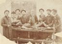
| Description: | Group of medical students (?) and instructor (?) posed around a cadaver. Presented by Dr. John G. Meachem III of Racine, Wis. Probably a dissection class a... |

| Date: | 1896 |
|---|---|
| Description: | An outdoor portrait of two men with a tandem bicycle. The men stand in a yard near a front walk leading up to a porch. In back of the men is the side of a ... |
| Date: | 1896 |
|---|---|
| Description: | Group portrait of men and women at a gathering at Jolly Lodge. The men are wearing knickerbockers, and the women are wearing long skirts with puffy sleeved... |

| Date: | 1896 |
|---|---|
| Description: | This map shows plat of town, local streets, numbered blocks and lots, mill pond, mills, part of the Red Cedar River, and land and property ownership by nam... |
| Date: | 1896 |
|---|---|
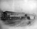
| Description: | View across railroad tracks towards a group of glee, banjo and mandolin club members posing in front of a University of Wisconsin banner on the Chicago and... |

| Date: | 1896 |
|---|---|
| Description: | Front cover and interior of banquet menu for Mexican President Porfirio Diaz, to celebrate the construction of a drainage canal between Lake Texcoco and La... |

| Date: | 1896 |
|---|---|
| Description: | This map shows railroads, churches, schools, cemeteries, rivers, lakes, and some rural property owners. |

| Date: | 1896 |
|---|---|
| Description: | A map of Lincoln, Oneida, and Vilas counties, which also includes part of Iron, Price, and Langlade counties. |

| Date: | 1896 |
|---|---|
| Description: | Elevated night view of the eight story Germania Building, which is illuminated with a multitude of individual electric light bulbs outlining the windows an... |
| Date: | 1896 |
|---|---|
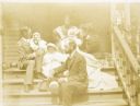
| Description: | The Holt and Stroh families are sitting together on the front steps of the Holts' home. On the left, W.A. Holt is holding his daughter Jeannette with her d... |
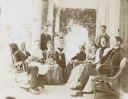
| Date: | 1896 |
|---|---|
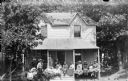
| Description: | A group of Holt and Rumsey family members (3 generations) and others are gathered on the porch of The Evergreens, the Rumsey estate, to see baby Jeannette ... |
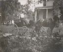
| Date: | 1896 |
|---|---|
| Description: | Holding the whip, Lucy Rumsey Holt is driving the carriage with Minnie May Rumsey sitting beside her. The Evergreens, the Rumsey estate is in the backgroun... |

| Date: | 1896 |
|---|---|
| Description: | View down street towards the George Walter Brewing Company. A large group of people are posing on the street with horse-drawn carriages and horse-drawn wag... |
If you didn't find the material you searched for, our Library Reference Staff can help.
Call our reference desk at 608-264-6535 or email us at: