 Filter: Categories of Wisconsin Historical Images
Filter: FULL_DATE of 1894
Filter: Subject of water
Filter: Categories of Wisconsin Historical Images
Filter: FULL_DATE of 1894
Filter: Subject of water
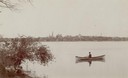
| Date: | 1894 |
|---|---|
| Description: | Man in a rowboat on Lake Monona with a view of the city in the background. |
| Date: | 1894 |
|---|---|
| Description: | Elevated view of the town as it appeared following the fire of 1894. |
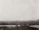
| Date: | 1894 |
|---|---|
| Description: | Panoramic view of Rochester and the Beaver Valley. Junction of the Beaver River and the Ohio River. Settlements and multiple bridges are in the background. |
| Date: | 1894 |
|---|---|
| Description: | A view from Pleasure Park. The Wisconsin State Capitol is seen across the lake and is framed by two trees in the foreground. |

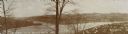
| Date: | 1894 |
|---|---|
| Description: | Everetta Bass, holding a basket of flowers, and her mother Ada on a hill by the mill pond (Montello Lake). The far shoreline of the lake can be seen in the... |

| Date: | 1894 |
|---|---|
| Description: | Panoramic view from shoreline of the Wisconsin River in the Wisconsin Dells as seen from the "Old Dell House." A canoe is visible on the shore on the far r... |

| Date: | 1894 |
|---|---|
| Description: | Panoramic view from shoreline of the Wisconsin River in the Wisconsin Dells. A sandy beach area is on the right, and rock formations are on both sides of t... |
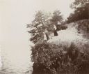
| Date: | 1894 |
|---|---|
| Description: | Elevated view of three women and a young girl standing at the edge of a small cliff on the shores of Lake Mendota. Various shrubs and small trees grow on t... |

| Date: | 1894 |
|---|---|
| Description: | Sanborn Map of the Illinois Steel Co. Bay View Works in Milwaukee. |

| Date: | 1894 |
|---|---|
| Description: | A detail of a Wisconsin map showing Sawyer, Chippewa and Price counties. |

| Date: | 1894 |
|---|---|
| Description: | A map of the state of Wisconsin sectioned by county. Scale: eight miles to the inch. |

| Date: | 1894 |
|---|---|
| Description: | This map shows lot and block numbers, railroads, street car tracks, sewers, water mains, gas mains, paved streets, land owned by the Land & River Improveme... |

| Date: | 1894 |
|---|---|
| Description: | Sanborn map of Milwaukee, with the Milwaukee River on the left, and Water Street in the center. There are two iron draw bridges over the river. |

| Date: | 1894 |
|---|---|
| Description: | This map shows railroads, street railways, roads, wards, block numbers, parks, Lake Michigan, and one mile concentric circles indicating distance from the ... |

| Date: | 1894 |
|---|---|
| Description: | This map shows sewers, intercepting sewers, manholes, block numbers, streets, railroads, parks, cemeteries, and Lake Michigan. The right margin reads: "Tot... |

| Date: | 1894 |
|---|---|
| Description: | Outdoor group portrait of Western Canoe Association members lounging in front of their tent camp. They are all wearing caps or hats. Near the center of the... |

| Date: | 1894 |
|---|---|
| Description: | This map shows railroads, street railways, ward lines, land parcels, streets, schools and public buildings. Ward lines are highlighted in red. Lake Michiga... |

| Date: | 1894 |
|---|---|
| Description: | This map shows automobile routes across the state and into parts of Illinois, Michigan, Minnesota, and Iowa. Cities, counties, Lake Michigan, Lake Superior... |

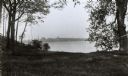
| Date: | 1894 |
|---|---|
| Description: | View across water towards a lakeside cottage in Chippewa county. |

| Date: | 1894 |
|---|---|
| Description: | This map shows the entire state with railroad routes shown in red, blue, orange, green, brown, pink, green, and black. Also labeled are counties, cities, t... |
If you didn't find the material you searched for, our Library Reference Staff can help.
Call our reference desk at 608-264-6535 or email us at: