 Filter: Categories of Wisconsin Historical Images
Filter: FULL_DATE of 1893
Filter: Subject of cities and towns
Filter: Categories of Wisconsin Historical Images
Filter: FULL_DATE of 1893
Filter: Subject of cities and towns
| Date: | 1893 |
|---|---|
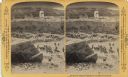
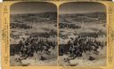
| Description: | A depiction of Jerusalem on the day of Jesus' crucifixion. In the foreground is a crowd of people, animals, and tents. There is also a group of solders wi... |
| Date: | 1893 |
|---|---|
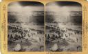
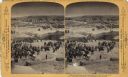
| Description: | A depiction of Akra in Jerusalem on the day of Jesus' crucifixion. A busy landscape of people, animals, and shelters. |
| Date: | 1893 |
|---|---|
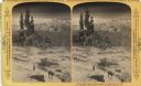
| Description: | A depiction of Jerusalem on the day of Jesus' crucifixion. This may be the Eastern end of Mount Zion or the City of David. Text at right: "Wanderings Among... |
| Date: | 1893 |
|---|---|
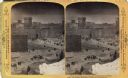
| Description: | A depiction of Jerusalem on the day of Jesus' crucifixion. In the background, there is Herodian architecture and the Hezekiah's Pool.Text at right: "Wander... |
| Date: | 1893 |
|---|---|
| Description: | A depiction of the Tower of Phasealis on the day of Jesus' crucifixion. |
| Date: | 1893 |
|---|---|
| Description: | A replication of the crucifixion of Jesus Christ. Depicted is the Damascus Road and the garden of Joseph of Arimathea. Joseph of Arimathea was a wealthy ma... |
| Date: | 1893 |
|---|---|
| Description: | A replication of the crucifixion of Jesus Christ. Depicted is the garden of Joseph of Arimathea and the tomb where Jesus is believed to be the buried. A Ro... |

| Date: | 1893 |
|---|---|
| Description: | View of the canal area of the Columbian Exposition grounds looking north from near the front of the Machinery building (at left). The South canal is in the... |
| Date: | 1893 |
|---|---|
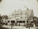
| Description: | The Wisconsin Building at the Chicago World's Fair (Columbian Exposition). |
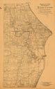
| Date: | 1893 |
|---|---|
| Description: | This 1893 map of the eastern portion of Racine County, Wisconsin, shows land ownership and acreages, railroads, and roads in the towns of Caledonia and Mou... |

| Date: | 1893 |
|---|---|
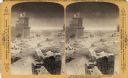
| Description: | Bird’s-eye view of Depere looking North. Includes illustrations and an index to points of interest. |
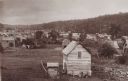
| Date: | 1893 |
|---|---|
| Description: | Valley view of town buildings and hillside. |

| Date: | 1893 |
|---|---|
| Description: | This map of La Crosse shows city ward boundaries in red, streets, railroads, cemeteries, Grand station crossing, the road to French Island, depots, Lake Pa... |

| Date: | 1893 |
|---|---|
| Description: | Map of Wisconsin showing Michigan's upper peninsula, the northern portion of Illinois and part of eastern Minnesota. There is an inset map of Isle Royale i... |
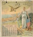
| Date: | 1893 |
|---|---|
| Description: | Calendar front, with the month of January, 1893. At the top it reads: "1893 calendar presented to the farmers of the world with the compliments of Aultman,... |
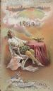
| Date: | 1893 |
|---|---|
| Description: | Front cover of a brochure for Champion Mowers and Binders. Features a color illustration of a man reclining in a chair, while holding a large sheet of pape... |
| Date: | 1893 |
|---|---|
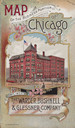
| Description: | Front cover of a brochure for Champion Mowers and Binders. Features a color illustration of the office building of the Warder, Bushnell and Glessner Compan... |
| Date: | 1893 |
|---|---|
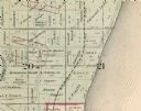
| Description: | Detail of a Milwaukee County map that shows sections 20 and 21 at Range 22 East, Township 8 North. |

| Date: | 1893 |
|---|---|
| Description: | This map shows wards, railroads, street cars, streets, lot and block numbers, landownership, parks, hospitals, the Sheboygan River, and Lake Michigan. Ward... |
| Date: | 1893 |
|---|---|
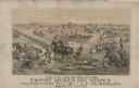
| Description: | Lithograph of the Empire Mower and Reaper; several other reaper manufacturers and models are identified in the illustration which appears above the text: “... |
If you didn't find the material you searched for, our Library Reference Staff can help.
Call our reference desk at 608-264-6535 or email us at: