 Filter: Categories of Wisconsin Historical Images
Filter: FULL_DATE of 1891
Filter: Subject of industries
Filter: Categories of Wisconsin Historical Images
Filter: FULL_DATE of 1891
Filter: Subject of industries

| Date: | 1891 |
|---|---|
| Description: | Bird's-eye view of Eau Claire. |
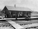
| Date: | 1891 |
|---|---|
| Description: | Elevated view across railroad tracks of the Wisconsin Central Railroad depot. Virtually the entire population of Sherry is thought to be standing on the pl... |

| Date: | 1891 |
|---|---|
| Description: | Elevated view of a barn raising on the farm of Alva Paddock in the township of Salem on Geneva Road, Highway 50. |

| Date: | 1891 |
|---|---|
| Description: | Lumber company workers pose in front of buildings at the Moore & Galloway Lumber Company camp, about a quarter of a mile east of Pike Lake. The man in a wh... |

| Date: | 1891 |
|---|---|
| Description: | This hand-colored map shows platted additions and subdivisions, ward boundaries, schools, churches, railroads, cemeteries, parks, businesses, factories, an... |

| Date: | 1891 |
|---|---|
| Description: | This map shows vacant Southwick & Sellers lands, settlers' houses, Goodland Co. land, schools, churches, saw mills, roads, and railroads. A key in the uppe... |
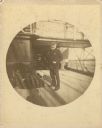
| Date: | 1891 |
|---|---|
| Description: | Frederick Layton standing on deck smoking a cigar while at sea in a Kodak #2 camera portrait by T.W. Ingersoll from St. Paul, Minnesota. The photographer's... |
If you didn't find the material you searched for, our Library Reference Staff can help.
Call our reference desk at 608-264-6535 or email us at: