 Filter: Categories of Wisconsin Historical Images
Filter: FULL_DATE of 1891
Filter: Subject of architecture
Filter: Categories of Wisconsin Historical Images
Filter: FULL_DATE of 1891
Filter: Subject of architecture
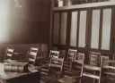
| Date: | 1891 |
|---|---|
| Description: | "Recitation Room" at Downer College. |

| Date: | 1891 |
|---|---|
| Description: | This map shows railroads, electric street railways, block numbers, docks, roads, parks, light houses, selected buildings, and sites for manufacturers. The ... |

| Date: | 1891 |
|---|---|
| Description: | Large group of people posed in, on and around the frame of a barn at a barn raising. A smaller building is in the background on the left. Cultivated fields... |

| Date: | 1891 |
|---|---|
| Description: | This hand-colored map shows platted additions and subdivisions, ward boundaries, schools, churches, railroads, cemeteries, parks, businesses, factories, an... |

| Date: | 1891 |
|---|---|
| Description: | This map shows vacant Southwick & Sellers lands, settlers' houses, Goodland Co. land, schools, churches, saw mills, roads, and railroads. A key in the uppe... |

| Date: | 1891 |
|---|---|
| Description: | Elevated view of First and Main Streets. A banner promoting the 1891 Wisconsin State Fair is posted on the side of a building. |

| Date: | 1891 |
|---|---|
| Description: | This blueprint manuscript map shows land owned by Green Bay & Mississippi Canal Co., Meade, Vilas, Patten, and Hewitt. Streets and the Fox River are labele... |

| Date: | 1891 |
|---|---|
| Description: | This blueprint manuscript map shows land owned by Kaukauna Water Power Co., Green Bay & Mississippi Canal Co., A.W. Patten, N.M. Edwards, and M.J. Meade. P... |

| Date: | 1891 |
|---|---|
| Description: | This map shows soft marshland, water channels, solid ground, club boundary and shooting boxes. Big Lake, First Channel, Second Channel, Fout Mile Pond, Mal... |
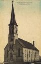
| Date: | 1891 |
|---|---|
| Description: | Hand-colored view of First Imanuels Church. A brick building with arched windows, bell tower and steeple. Caption reads: "First Imanuels Church, Cedarburg,... |
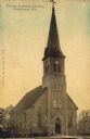
| Date: | 1891 |
|---|---|
| Description: | Hand-colored view of Trinity Lutheran Church on Columbia Road, a stone building with a clock in the bell tower/steeple. Arched windows are on the front and... |
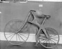
| Date: | 1891 |
|---|---|
| Description: | Wooden bicycle on display against a wall at the Wisconsin State Historical Museum, circa 1920. It is known as the "Crabtree Special" because it was reporte... |

| Date: | 1891 |
|---|---|
| Description: | View down tree-lined sidewalk along Marshall Street facing west. The northwest corner of S. 6th and Marshall Streets is circled by a fence, which continue... |

| Date: | 1891 |
|---|---|
| Description: | View of the George Ruder Brewing Company. A group of men and a dog are posing near an entrance on the side of the brick building. A man is on a horse-drawn... |

| Date: | 1891 |
|---|---|
| Description: | The index page of a Sanborn Map of Stevens Point. |
If you didn't find the material you searched for, our Library Reference Staff can help.
Call our reference desk at 608-264-6535 or email us at: