 Filter: Categories of Wisconsin Historical Images
Filter: FULL_DATE of 1891
Filter: Subject of architecture
Filter: Subject of human settlements
Filter: Categories of Wisconsin Historical Images
Filter: FULL_DATE of 1891
Filter: Subject of architecture
Filter: Subject of human settlements
| Date: | 1891 |
|---|---|
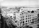
| Description: | Elevated view looking west from the Knight Block. The Chequamegon Hotel and harbor are in the background. |
| Date: | 1891 |
|---|---|
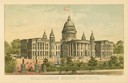
| Description: | Chromolithograph of the third Wisconsin State Capitol with a U.S. flag atop the dome. The colored illustration was produced by the Milwaukee Lithography an... |

| Date: | 1891 |
|---|---|
| Description: | Bird's-eye map of Wausau, looking north with ninety-eight businesses, industries, churches, schools, and civic buildings identified in location key below i... |

| Date: | 1891 |
|---|---|
| Description: | Bird's-eye view of Eau Claire. |

| Date: | 1891 |
|---|---|
| Description: | Bird's-eye map of Stevens Point, looking east, with an inset of the Water Works. Wisconsin River in foreground with fifty-three business locations identifi... |
| Date: | 1891 |
|---|---|
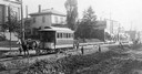
| Description: | View across road construction towards a horse-drawn trolley on railroad tracks on Racine Street. Men and children are standing near piles of road building ... |
| Date: | 1891 |
|---|---|
| Description: | Lithograph view of The Pabst German Stadt Theater on Oneida Street in Milwaukee, Wis. |
| Date: | 1891 |
|---|---|
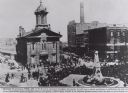
| Description: | Elevated view of fountain in front of the old City Hall, with a memorial to Henry Bergh (?-1888), founder of the American Humane Society. Several other bui... |
| Date: | 1891 |
|---|---|
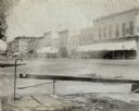
| Description: | View from corner of storefronts. Horse-drawn vehicles and pedestrians are in the street. There is a water fountain with a cup in the foreground. |
| Date: | 1891 |
|---|---|
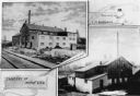
| Description: | Composite photograph showing the tanneries of L.M. Sherman and Henry Vits. |
| Date: | 1891 |
|---|---|
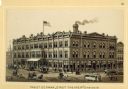
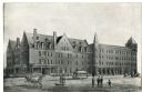
| Description: | Exterior view of the West Superior Hotel. There are pedestrians, a street car, and people riding in horse-drawn carriages on the street in front of the hot... |

| Date: | 1891 |
|---|---|
| Description: | Color illustration of the grounds and buildings of the 1893 World's Fair or Columbian Exposition. |

| Date: | 1891 |
|---|---|
| Description: | A hand-colored map of Milwaukee County, Wisconsin that shows the township and range system, sections, towns, roads, railroads and rail stations, cities and... |

| Date: | 1891 |
|---|---|
| Description: | This late 19th century map shows the lake region around Oconomowoc in Waukesha County and eastern Jefferson County, Wisconsin. The township and range grid,... |

| Date: | 1891 |
|---|---|
| Description: | This maps has an index of depots, hotels, prominent institutions and buildings, churches, and places of amusement. The map was removed from an unidentified... |

| Date: | 1891 |
|---|---|
| Description: | This hand-colored map shows platted additions and subdivisions, ward boundaries, schools, churches, railroads, cemeteries, parks, businesses, factories, an... |

| Date: | 1891 |
|---|---|
| Description: | This map shows vacant Southwick & Sellers lands, settlers' houses, Goodland Co. land, schools, churches, saw mills, roads, and railroads. A key in the uppe... |

| Date: | 1891 |
|---|---|
| Description: | Elevated view of First and Main Streets. A banner promoting the 1891 Wisconsin State Fair is posted on the side of a building. |

| Date: | 1891 |
|---|---|
| Description: | This blueprint manuscript map shows land owned by Green Bay & Mississippi Canal Co., Meade, Vilas, Patten, and Hewitt. Streets and the Fox River are labele... |

| Date: | 1891 |
|---|---|
| Description: | This blueprint manuscript map shows land owned by Kaukauna Water Power Co., Green Bay & Mississippi Canal Co., A.W. Patten, N.M. Edwards, and M.J. Meade. P... |
If you didn't find the material you searched for, our Library Reference Staff can help.
Call our reference desk at 608-264-6535 or email us at: