Filter: Categories of Wisconsin Historical Images
Filter: FULL_DATE of 1891
Filter: Reproduction Rights of For Sale
Filter: Subject of land
Filter: Categories of Wisconsin Historical Images
Filter: FULL_DATE of 1891
Filter: Reproduction Rights of For Sale
Filter: Subject of land

| Date: | 1891 |
|---|---|
| Description: | Bird's-eye view of Eau Claire. |

| Date: | 1891 |
|---|---|
| Description: | Bird's-eye map of Stevens Point, looking east, with an inset of the Water Works. Wisconsin River in foreground with fifty-three business locations identifi... |

| Date: | 1891 |
|---|---|
| Description: | A deeply rutted dirt road leads to a bridge over a river. Buildings are on both sides of the river. Bluffs and hills with trees are in the background. This... |

| Date: | 1891 |
|---|---|
| Description: | Map shows Iron and Dickinson Counties, Mich. and Florence County, Wis. "Nov. 1st, 1891." Irregularly shaped. Includes table of distances and township diagr... |

| Date: | 1891 |
|---|---|
| Description: | This late 19th century map shows the lake region around Oconomowoc in Waukesha County and eastern Jefferson County, Wisconsin. The township and range grid,... |

| Date: | 1891 |
|---|---|
| Description: | This map of La Crosse shows eighteen city wards in red, railroads, cemeteries, fair grounds, labeled streets, islands, and the Mississippi River. The left ... |

| Date: | 1891 |
|---|---|
| Description: | This colorful map shows additions, railroads, docks, streets, established dock lines, marshes, and proposed belt line railroad. The map covers west and sou... |
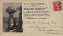
| Date: | 1891 |
|---|---|
| Description: | H.H. Bennett advertising envelope addressed to William H. Metcalf of Milwaukee. The envelope bears an engraved image of people standing on top of Stand Roc... |

| Date: | 1891 |
|---|---|
| Description: | This blueprint manuscript map shows land owned by Green Bay & Mississippi Canal Co., Meade, Vilas, Patten, and Hewitt. Streets and the Fox River are labele... |

| Date: | 1891 |
|---|---|
| Description: | This blueprint manuscript map shows land owned by Kaukauna Water Power Co., Green Bay & Mississippi Canal Co., A.W. Patten, N.M. Edwards, and M.J. Meade. P... |

| Date: | 1891 |
|---|---|
| Description: | This map shows soft marshland, water channels, solid ground, club boundary and shooting boxes. Big Lake, First Channel, Second Channel, Fout Mile Pond, Mal... |

| Date: | 1891 |
|---|---|
| Description: | This map shows soft marshland, water channels, solid ground, club boundary and shooting boxes. Big Lake, First Channel, Second Channel, Fout Mile Pond, Mal... |

| Date: | 1891 |
|---|---|
| Description: | The index page of a Sanborn Map of Stevens Point. |

| Date: | 1891 |
|---|---|
| Description: | Page 13 of a Sanborn map of Stevens Point. |
If you didn't find the material you searched for, our Library Reference Staff can help.
Call our reference desk at 608-264-6535 or email us at: