Filter: Categories of Wisconsin Historical Images
Filter: FULL_DATE of 1890
Filter: Subject of railroads
Filter: Categories of Wisconsin Historical Images
Filter: FULL_DATE of 1890
Filter: Subject of railroads
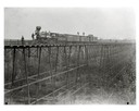
| Date: | 1890 |
|---|---|
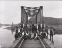
| Description: | Wisconsin Central Railroad train on White River Bridge, with crew posing on top of cars. The bridge was 1600 feet long and 110 feet above the water. In 187... |

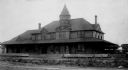
| Date: | 1890 |
|---|---|
| Description: | People and carriages in front of the depot-hotel Railway Hotel on West Washington Avenue. This was the Chicago, Milwaukee, and St. Paul Railway Ticket Offi... |

| Date: | 1890 |
|---|---|
| Description: | Bird's-eye map of Beloit with insets of Williams Engine Works, Eclipse Wind Engine Co., and John Foster & Co. Turtle Creek is in the lower section, and the... |
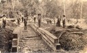
| Date: | 1890 |
|---|---|
| Description: | Men building a culvert on the Milwaukee, Lake Shore & Westerm railway. In the background both horses and oxen teams are being used. |

| Date: | 1890 |
|---|---|
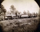
| Description: | View looking down railroad tracks towards the Chicago, Milwaukee and St. Paul Railroad locomotive #240, a type 4-4-0. On the right is a steep, rocky bank, ... |
| Date: | 1890 |
|---|---|
| Description: | Crew from the Augusta and Knoxville railroad posing with a steam engine. |

| Date: | 1890 |
|---|---|
| Description: | Left half of a plat map of the "East Part of the city of Madison". |

| Date: | 1890 |
|---|---|
| Description: | Right side of a plat map of the "East Part of the City of Madison". |

| Date: | 1890 |
|---|---|
| Description: | This map shows lakes, railroads, and rivers. An explanation of railroad lines with mileage in Wisconsin and total mileage for 1890 is included. Portions of... |
| Date: | 1890 |
|---|---|
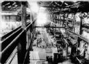
| Description: | Interior of the Wisconsin Central Railway's Waukesha back shop. The elevated view is from the office of the superintendent. |

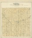
| Date: | 1890 |
|---|---|
| Description: | A plat map of a portion of Verona in Dane County. |
| Date: | 1890 |
|---|---|
| Description: | A railroad section crew poses with a handcar on the trestle spanning the Buffalo River, north of Alma, Wisconsin. |
| Date: | 1890 |
|---|---|
| Description: | "For prices, terms and all particulars regarding these lands, apply to Charles E. Simmons, Land Commissioner, Chicago & North-Western Railway, Chicago, Ill... |

| Date: | 1890 |
|---|---|
| Description: | A map of Wisconsin, eastern Wisconsin and Iowa, northern Illinois, and the Upper Peninsula of Michigan. The counties, cities and villages, and rail lines i... |

| Date: | 1890 |
|---|---|
| Description: | This late 19th century map shows mining companies' lands and miscellaneous properties in the towns of Cady and Springfield in southeastern Saint Croix Coun... |

| Date: | 1890 |
|---|---|
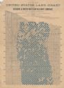
| Description: | This map shows the Wisconsin Central Railroad land grant lands owned and for sale by the Soo Line in Ashland County, Wisconsin, as well as in portions of B... |
If you didn't find the material you searched for, our Library Reference Staff can help.
Call our reference desk at 608-264-6535 or email us at: