 Filter: Categories of Wisconsin Historical Images
Filter: FULL_DATE of 1890
Filter: Subject of parks
Filter: Categories of Wisconsin Historical Images
Filter: FULL_DATE of 1890
Filter: Subject of parks
| Date: | 1890 |
|---|---|
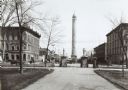
| Description: | The Madison water tower and farmers' market as seen through the stone gateway at the East Washington Avenue entrance to the Capitol Park. The building on t... |

| Date: | 1890 |
|---|---|
| Description: | Bird's-eye map of Ashland, viewed from Lake Superior, with insets of Prentice Park and Fishery. Population 16,000. Increase in Ten Years, 11,000. |
| Date: | 1890 |
|---|---|
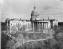
| Description: | The expanded third Wisconsin State Capitol photographed at a time of the year when the trees in the park did not obstruct the view. As a result, the curvil... |

| Date: | 1890 |
|---|---|
| Description: | A view looking down Wisconsin Avenue as seen from the Wisconsin State Capitol grounds. On the right, the post office is visible. |

| Date: | 1890 |
|---|---|
| Description: | This map is a plat map and shows government buildings, churches, Klein’s Park, and the government dam in Kaukauna. The map includes text about Kaukauna wit... |

| Date: | 1890 |
|---|---|
| Description: | This map shows lot and block numbers, established dock lines, docks, slips, railroads, streets, selected industrial buildings, sites for manufactories, and... |

| Date: | 1890 |
|---|---|
| Description: | This map shows lot and block numbers and dimensions, landownership, city wards, buildings, streets, railroads, parks, cemeteries, churches, schools, and in... |
| Date: | 1890 |
|---|---|
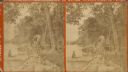
| Description: | Stereograph view along shoreline of Geneva Lake at Porter's Park. A man sits in a canoe at the rocky shoreline while a woman sits and reads on a rustic ben... |
| Date: | 1890 |
|---|---|
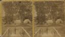
| Description: | Stereograph view from footbridge with rustic railings of a small boy wearing a large hat standing at the end of the footbridge. A group of adults and anoth... |

| Date: | 1890 |
|---|---|
| Description: | This map shows city wards, block numbers, parks, cemeteries, roads, railroads, and selected buildings. The map includes indexes to streets, public building... |

| Date: | 1890 |
|---|---|
| Description: | View from pier of groups of people walking along a Lake Monona dock and on the walkway to the shore. On the right is an excursion boat with a United States... |
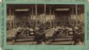
| Date: | 1890 |
|---|---|
| Description: | Stereograph of the interior of the Tabernacle during the Monona Lake Assembly. The assembly, Madison's annual Chautauqua, was held on the site of the prese... |
If you didn't find the material you searched for, our Library Reference Staff can help.
Call our reference desk at 608-264-6535 or email us at: