Filter: Categories of Wisconsin Historical Images
Filter: FULL_DATE of 1889
Filter: Subject of transportation
Filter: Subject of water
Filter: Categories of Wisconsin Historical Images
Filter: FULL_DATE of 1889
Filter: Subject of transportation
Filter: Subject of water
| Date: | 1889 |
|---|---|
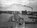
| Description: | Elevated view of bridge crossing the wide Fox River, with the paper mill on the far side of the river, and a horse-drawn cart approaching the near side. |
| Date: | 1889 |
|---|---|
| Description: | Elevated view of Washington Street and the Fox River and buildings nearby. |
| Date: | 1889 |
|---|---|
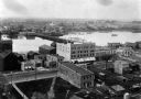
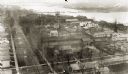
| Description: | Elevated view looking north toward the harbor with multiple buildings in the foreground. |
| Date: | 1889 |
|---|---|
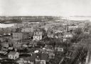
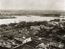
| Description: | View of Green Bay from the top of St. Willibrord's Church. A river can be seen in the background. |
| Date: | 1889 |
|---|---|
| Description: | Southwest view of the Fox River and the waterfront. |
| Date: | 1889 |
|---|---|
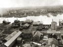
| Description: | Elevated view of an industrial waterfront along the Fox River. |

| Date: | 1889 |
|---|---|
| Description: | View of the Fox River between Green Bay and Fort Howard. |

| Date: | 1889 |
|---|---|
| Description: | From a map published by Angell and Hastreither, the drawing depicts the Tonyawatha Spring Hotel grounds on Lake Monona. The hotel, located in Blooming Grov... |

| Date: | 1889 |
|---|---|
| Description: | Chicago & North Western Railway viaduct on the line along the Milwaukee River. The viaduct has two arched passages, and stones and rocks lining the path f... |

| Date: | 1889 |
|---|---|
| Description: | Looking down street toward Lake Michigan, which is visible at the end of the road. The dirt street is lined with trees and houses. On the right stands a... |
| Date: | 1889 |
|---|---|
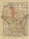
| Description: | A map that shows the railroad's lines in Wisconsin, northern Illinois, and the Upper Peninsula of Michigan. Those that are marked with a red line are those... |

| Date: | 1889 |
|---|---|
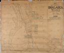
| Description: | This 1889 map of Douglas County, Wisconsin, shows the township and range grid, towns, sections, cities and villages, roads, existing and proposed railroads... |

| Date: | 1889 |
|---|---|
| Description: | Shows city limits, railroads, mills, schools, cemeteries, dams, parks, lumber yards, log canals, log reservoir, Chippewa River, Eau Claire River, and Half ... |
| Date: | 1889 |
|---|---|
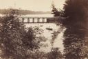
| Description: | View from shoreline looking down on Mud Creek, about two miles above De Pere, showing small bridge and a man in a rowboat. |

| Date: | 1889 |
|---|---|
| Description: | This map shows a plat of city, city limits, numbered blocks, numbered lots, wards, local streets, roads, railroads, street railways, fire limits, hydrants,... |

| Date: | 1889 |
|---|---|
| Description: | This map shows lot and block numbers, established dock lines, docks, slips, railroads, and streets of West Superior in 1889. |
| Date: | 1889 |
|---|---|
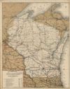
| Description: | This map shows lakes, railroads, and rivers. An explanation of railroad lines with mileage in Wisconsin and total mileage for 1889 is included. Portions of... |

| Date: | 1889 |
|---|---|
| Description: | This map lists township and section numbers outside municipality, housing additions and subdivisions and plat owners outside municipality, the Black River,... |
| Date: | 1889 |
|---|---|
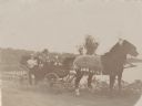
| Description: | A family posing in an open carriage pulled by a matched team of horses on the shore of Rock Lake near Lake Mills. A handwritten caption identifies the fami... |
If you didn't find the material you searched for, our Library Reference Staff can help.
Call our reference desk at 608-264-6535 or email us at: