Filter: Categories of Wisconsin Historical Images
Filter: FULL_DATE of 1889
Filter: Type of Map or Atlas
Filter: Subject of rivers
Filter: Categories of Wisconsin Historical Images
Filter: FULL_DATE of 1889
Filter: Type of Map or Atlas
Filter: Subject of rivers
| Date: | 1889 |
|---|---|
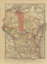
| Description: | A map that shows the railroad's lines in Wisconsin, northern Illinois, and the Upper Peninsula of Michigan. Those that are marked with a red line are those... |

| Date: | 1889 |
|---|---|
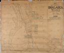
| Description: | Bird’s-eye-view map. Published in the Milwaukee Sentinel: Wednesday morning, August 28, 1889 for the 23rd National Encampments of the GAR, August 27... |

| Date: | 1889 |
|---|---|
| Description: | Shows city limits, railroads, mills, schools, cemeteries, dams, parks, lumber yards, log canals, log reservoir, Chippewa River, Eau Claire River, and Half ... |
| Date: | 1889 |
|---|---|
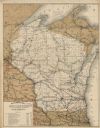
| Description: | This map shows lakes, railroads, and rivers. An explanation of railroad lines with mileage in Wisconsin and total mileage for 1889 is included. Portions of... |

| Date: | 1889 |
|---|---|
| Description: | This map lists township and section numbers outside municipality, housing additions and subdivisions and plat owners outside municipality, the Black River,... |
| Date: | 1889 |
|---|---|
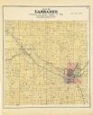
| Description: | A plat map of Larrabee, township 25 north, range 14 east. |
If you didn't find the material you searched for, our Library Reference Staff can help.
Call our reference desk at 608-264-6535 or email us at: