Filter: Categories of Wisconsin Historical Images
Filter: FULL_DATE of 1888
Filter: Subject of water
Filter: Categories of Wisconsin Historical Images
Filter: FULL_DATE of 1888
Filter: Subject of water
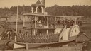
| Date: | 1888 |
|---|---|
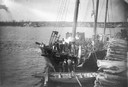
| Description: | Elevated view of men repairing a docked, damaged ship. A shoreline is in the distance. |
| Date: | 1888 |
|---|---|
| Description: | View of shoreline along Picnic Point on the University of Wisconsin-Madison campus showing the home of Professor William Daniels, head of the Chemistry Dep... |
| Date: | 1888 |
|---|---|
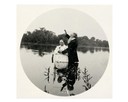
| Description: | Members of the Kilbourn Broom Brigade on the Alexander Mitchell steamboat in the Dells. Members of the group include: Minnie Smith, Mary Sterlie, Ru... |
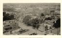
| Date: | 1888 |
|---|---|
| Description: | Elevated view from the northwest of the Racine Court House. Caption reads: "Birds-Eye from Court House, Northwest." |
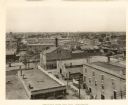
| Date: | 1888 |
|---|---|
| Description: | Elevated view looking northwest from Racine City Hall. Caption reads: "Bird's-Eye View from City Hall, Northwest." |
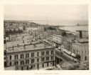
| Date: | 1888 |
|---|---|
| Description: | Elevated view from the Racine Court House of northeast Racine, with Lake Michigan on the right. Caption reads: "Bird's-Eye from Court House." |

| Date: | 1888 |
|---|---|
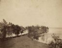
| Description: | View of Picnic Point stretching out into Lake Mendota on the University of Wisconsin-Madison campus. |
| Date: | 1888 |
|---|---|
| Description: | View of Picnic Point on the University of Wisconsin-Madison campus. The peninsula juts into Lake Mendota. The far shoreline can be seen in the distance. |
| Date: | 1888 |
|---|---|
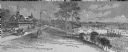
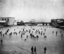
| Description: | Elevated view of a winter scene with a large group of people skating on the frozen Manitowoc River between the 8th and 10th Street bridges. A dog trots acr... |
| Date: | 1888 |
|---|---|
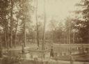
| Description: | Several adults, two children and a dog enjoying a pond at Bracken Brae, the country home of John Johnston (1836-1904), a successful Milwaukee banker. Hilda... |
| Date: | 1888 |
|---|---|
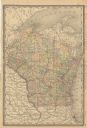
| Description: | A cloth mounted, hand-colored map of Wisconsin depicting the rail routes, counties, towns, rivers, and lakes throughout the state. Also included in the ma... |

| Date: | 1888 |
|---|---|
| Description: | This late 19th century map of Price County, Wisconsin, shows landownership and waterfront acreages, the township and range system, towns, cities and villag... |

| Date: | 1888 |
|---|---|
| Description: | Map of Milwaukee "Compiled under the direction of the J.V. DUPRE ABSTRACT CO., from Dupre’s 1/4-Sectn’l Atlas of Milwaukee, by G. Steinhagen, C.E." Contain... |
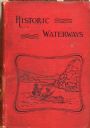
| Date: | 1888 |
|---|---|
| Description: | Front cover of Reuben Gold Thwaites' Historic Waterways, with an image of a man and a woman paddling a rowboat on a river. |

| Date: | 1888 |
|---|---|
| Description: | Shows ward divisions and street railways, as well as University of Wisconsin buildings, churches, and schools. Cataloged from copy with right and left edge... |

| Date: | 1888 |
|---|---|
| Description: | This map has relief shown by hachures and features inset maps of a plat of E.D. Clinton and Blackwell’s add’n to the City of La Crosse. Wards (1-10) shaded... |
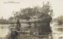
| Date: | 1888 |
|---|---|
| Description: | Photographic postcard view from shoreline of the rock formation in the Dells of the Wisconsin River. A man is paddling a canoe in the foreground. Printed o... |
If you didn't find the material you searched for, our Library Reference Staff can help.
Call our reference desk at 608-264-6535 or email us at: